Approximate Location Map
Large Map »
Latitude: 55.751 / 55°45'3"N
Longitude: -4.6275 / 4°37'39"W
OS Eastings: 235190
OS Northings: 653970
OS Grid: NS351539
Mapcode National: GBR 39.BR41
Mapcode Global: WH2NB.WQL3
Plus Code: 9C7QQ92C+9X
Entry Name: Boys Brigade Hall, Head Street, Beith
Listing Name: Head Street, Former United Free Church, Including Boundary Walls, Railings, Gates and Gatepiers
Listing Date: 14 April 1971
Category: B
Source: Historic Scotland
Source ID: 331342
Historic Scotland Designation Reference: LB898
Building Class: Cultural
ID on this website: 200331342
Location: Beith
County: North Ayrshire
Electoral Ward: Kilbirnie and Beith
Parish: Beith
Traditional County: Ayrshire
Tagged with: Church building Church hall
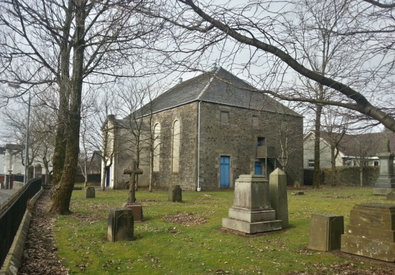
1784. Classical, 2-storey 5-bay rectangular-plan piend-roofed former church; later 20th century brick addition to W; all window openings blocked. 4 tall round-arched, keystoned windows; central, projecting porch with narrow side lights under shallow segmental-arched head with central pilastered, round-arched window above and outer pilasters supporting pediment; remains of apex stack. Random sandstone rubble with ashlar margins; rendered porch with polished ashlar dressings. Lean-to addition to rear.
Grey slates.
INTERIOR: altered. Timber panelled gallery remains to NE (filled in above); cantilevered pulpit over entrance. Kingpost roof structure.
BOUNDARY WALLS, RAILING GATES AND GATEPIERS: low coped rubble wall to Head Street with delicate fleur-de-lis cast-iron railings over; square droved ashlar gatepiers with domed caps; cast-iron gates. Coped rubble boundary wall to sides and rear enclosing burial ground containing some interesting late 18th and 19th century monuments.
In 1784, as a result of a break from the Established church, the church in Head Street was built as a Relief Church. In 1840 it presumably became the United Presbyterian Church. In 1900 the Free Church and the United Presbyterian Church merged becoming the United Free Church. By 1917 the church had ceased to be in ecclesiastical use and was then used as a dance hall, an Orange Lodge, a cinema and a factory. It is now principally used by the 1st Beith Boys' Brigade. The design is in appropriately restrained classicism. The loss of the glazing affects the character of the building however. The rubble walls were harled certainly until the late 20th century.
External links are from the relevant listing authority and, where applicable, Wikidata. Wikidata IDs may be related buildings as well as this specific building. If you want to add or update a link, you will need to do so by editing the Wikidata entry.


Other nearby listed buildings
