Approximate Location Map
Large Map »
Latitude: 57.4928 / 57°29'34"N
Longitude: -2.97 / 2°58'11"W
OS Eastings: 341954
OS Northings: 845149
OS Grid: NJ419451
Mapcode National: GBR M81X.L5J
Mapcode Global: WH7L9.BXYS
Plus Code: 9C9VF2VJ+42
Entry Name: Davidston House
Listing Name: Mains of Davidston
Listing Date: 24 November 1972
Category: B
Source: Historic Scotland
Source ID: 333992
Historic Scotland Designation Reference: LB3017
Building Class: Cultural
ID on this website: 200333992
Location: Cairnie
County: Aberdeenshire
Electoral Ward: Huntly, Strathbogie and Howe of Alford
Parish: Cairnie
Traditional County: Aberdeenshire
Tagged with: House
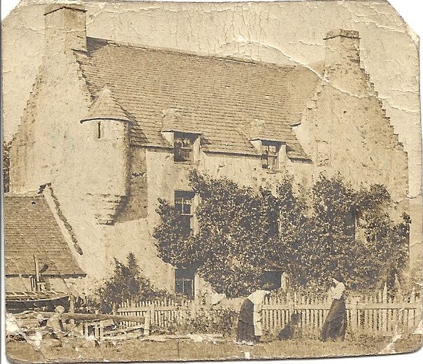
House; L Plan. Dated 1678 with late 18th Century finishings.
2 1/2 storeys. Rubble harle pointed slated roof with
piended dormers. Corbie steps, angle turrets. 1-storey wings at ends
of both arms. Steadings at rear with dovecot in loft of
one.
Derelict but intact. Originally Davidston House a Gordon
property.
External links are from the relevant listing authority and, where applicable, Wikidata. Wikidata IDs may be related buildings as well as this specific building. If you want to add or update a link, you will need to do so by editing the Wikidata entry.


Other nearby listed buildings
