Approximate Location Map
Large Map »
Latitude: 55.0228 / 55°1'22"N
Longitude: -3.2738 / 3°16'25"W
OS Eastings: 318659
OS Northings: 570549
OS Grid: NY186705
Mapcode National: GBR 5BLC.08
Mapcode Global: WH6Y6.P07S
Plus Code: 9C7R2PFG+4F
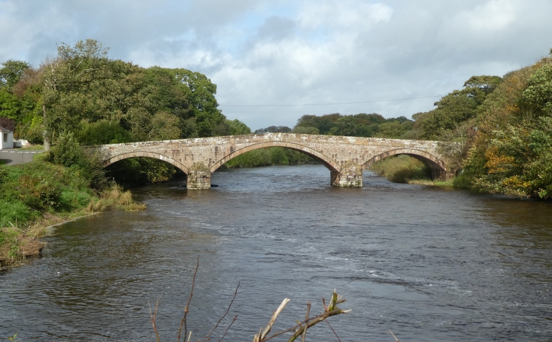
Entry Name: Brydekirk Bridge
Listing Name: Brydekirk Village, Brydekirk Bridge
Listing Date: 3 August 1971
Category: A
Source: Historic Scotland
Source ID: 334552
Historic Scotland Designation Reference: LB3494
Building Class: Cultural
ID on this website: 200334552
Location: Annan
County: Dumfries and Galloway
Electoral Ward: Annandale South
Parish: Annan
Traditional County: Dumfriesshire
Tagged with: Bridge Road bridge
Build circa 1817. Roadbridge, 3 segmental arches (roughly
15m-21m-15m) over River Annan. Courses and squared rubble
with ashlar recessed arch rings and ramped parapet coping;
pointed cutwaters either side.
Also in Hoddom parish.
Upgraded B to A 30.9.87
External links are from the relevant listing authority and, where applicable, Wikidata. Wikidata IDs may be related buildings as well as this specific building. If you want to add or update a link, you will need to do so by editing the Wikidata entry.


Other nearby listed buildings
