Approximate Location Map
Large Map »
Latitude: 55.0942 / 55°5'38"N
Longitude: -2.964 / 2°57'50"W
OS Eastings: 338578
OS Northings: 578172
OS Grid: NY385781
Mapcode National: GBR 79RJ.3P
Mapcode Global: WH7Z3.F7T2
Plus Code: 9C7V32VP+MC
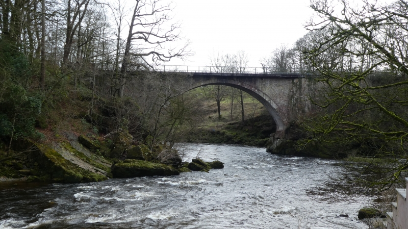
Entry Name: Gilnockie Bridge
Listing Name: Gilnockie Bridge (A7 over River Esk)
Listing Date: 3 August 1971
Category: A
Source: Historic Scotland
Source ID: 334562
Historic Scotland Designation Reference: LB3504
Building Class: Cultural
ID on this website: 200334562
Location: Canonbie
County: Dumfries and Galloway
Electoral Ward: Annandale East and Eskdale
Parish: Canonbie
Traditional County: Dumfriesshire
Tagged with: Bridge Road bridge
Built 1793. Roadbridge; 2 giant segmental arches (one over
Esk, other dry); roadway widened on cantilevers probably in
mid 20th century; massive masonry abutment between arches.
Modern plain iron parapets set in concrete.
Arches 70' and 45' span; 46' in height and 244' in length.
(Old Statistical Account)
Upgraded B to A 12.7.88.
External links are from the relevant listing authority and, where applicable, Wikidata. Wikidata IDs may be related buildings as well as this specific building. If you want to add or update a link, you will need to do so by editing the Wikidata entry.


Other nearby listed buildings
