Approximate Location Map
Large Map »
Latitude: 55.002 / 55°0'7"N
Longitude: -3.5199 / 3°31'11"W
OS Eastings: 302880
OS Northings: 568545
OS Grid: NY028685
Mapcode National: GBR 3BVL.RQ
Mapcode Global: WH5WY.XJ1S
Plus Code: 9C7R2F2J+Q3
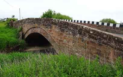
Entry Name: Bankend Bridge
Listing Name: Bankend Bridge (B725 over Lochar Water)
Listing Date: 3 August 1971
Category: B
Source: Historic Scotland
Source ID: 334950
Historic Scotland Designation Reference: LB3798
Building Class: Cultural
ID on this website: 200334950
Location: Caerlaverock
County: Dumfries and Galloway
Electoral Ward: Nith
Parish: Caerlaverock
Traditional County: Dumfriesshire
Tagged with: Road bridge
Completed 1813. Single segmental-span road bridge. Rubble
built, recessed red ashlar arch-ring ramped parapets
splayed at approaches, pyramidal caps to square terminal
piers.
Also in Ruthwell Parish. Last payment made 29.4.1813 (a sum
not exceeding $170 was allowed).
External links are from the relevant listing authority and, where applicable, Wikidata. Wikidata IDs may be related buildings as well as this specific building. If you want to add or update a link, you will need to do so by editing the Wikidata entry.


Other nearby listed buildings
