Approximate Location Map
Large Map »
Latitude: 56.0553 / 56°3'19"N
Longitude: -4.4537 / 4°27'13"W
OS Eastings: 247297
OS Northings: 687436
OS Grid: NS472874
Mapcode National: GBR 0R.QFFR
Mapcode Global: WH3N6.K2D7
Plus Code: 9C8Q3G4W+4G
Entry Name: Drymen Bridge
Listing Name: Drymen Bridge (Over Endrick Water)
Listing Date: 5 September 1973
Category: B
Source: Historic Scotland
Source ID: 335077
Historic Scotland Designation Reference: LB3900
Building Class: Cultural
ID on this website: 200335077
Location: Drymen
County: Stirling
Electoral Ward: Forth and Endrick
Parish: Drymen
Traditional County: Stirlingshire
Tagged with: Bridge
Loch Lomond And Trossachs National Park Planning Authority
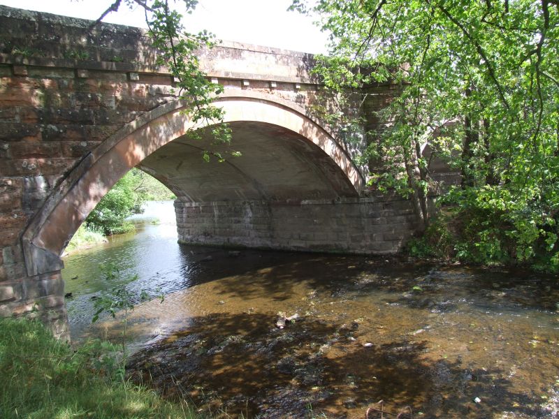
Probably 1765; widend and reconstructed 1929. Symmetrical 5-span road bridge with regularly-spaced segmental-headed arches. Coursed rock-faced sandstone with sandstone ashlar dressings; reconstructed concrete substructure visible to soffits. Ashlar voussoirs, arch rings and band course supported on regularly spaced dentil-like projecting blocks. Impost bands to arches. Squared coping chamfered at edges to parapet. Semicircular-plan turret projections to both central piers (on both sides); rounded cutwaters at base. Wings terminate at circular-plan piers.
Described as 'very handsome' in the New Statistical Account (1841, published 1845). The same source also gives its date of construction as 1765. It appears in identical plan-form (with 2 central cutwater piers) on the 1865 OS map and in a late 19th century photograph in Guthrie Smith's book. It was built along the turnpike road (established as a military road after 1745) from Glasgow to Dumbarton. The high quality of its design and execution might in part be owing to its close proximity to the main entrance to the Buchanan estate, principal seat of the Dukes of Montrose during the 18th and 19th centuries (as well as to its situation along a military/turnpike road). Considerable amounts of building work were being carried out on the estate throughout much of the 18th century. According to Scottish Country Life (1929) 'this beautiful stone viaduct replaces the high and narrow old bridge'.
External links are from the relevant listing authority and, where applicable, Wikidata. Wikidata IDs may be related buildings as well as this specific building. If you want to add or update a link, you will need to do so by editing the Wikidata entry.


Other nearby listed buildings
