Approximate Location Map
Large Map »
Latitude: 56.0657 / 56°3'56"N
Longitude: -4.4532 / 4°27'11"W
OS Eastings: 247371
OS Northings: 688592
OS Grid: NS473885
Mapcode National: GBR 0R.PTSW
Mapcode Global: WH3N0.KSNS
Plus Code: 9C8Q3G8W+7P
Entry Name: The Winnock Hotel, The Square, Drymen
Listing Name: Drymen, the Square, the Winnock
Listing Date: 5 September 1973
Category: B
Source: Historic Scotland
Source ID: 335087
Historic Scotland Designation Reference: LB3912
Building Class: Cultural
ID on this website: 200335087
Location: Drymen
County: Stirling
Electoral Ward: Forth and Endrick
Parish: Drymen
Traditional County: Stirlingshire
Tagged with: Hotel
Loch Lomond And Trossachs National Park Planning Authority
Late 18th/early 19th century with alterations and additions. 16-bay 2-storeyed terrace (grouped: 3/5/5/3), probably originally comprising 4 separate properties/cottages, now combined as hotel. Separate cottage arrangements most clearly visible to outer flanking 3-bay sections to principal (E) elevation. Mainly harled (painted rubble to central 10-bay section to principal elevation) with some painted stone dressings. Painted architraves to principal elevation apart from to 3-bay section to outer right.
E (PRINCIPAL) ELEVATION: main 10-bay section of hotel to centre; later 20th century glazed flat-roofed 2-bay entrance porch to 4th and 5th bays from left; entrance with glazed door to 2nd bay from left and one with part-glazed timber door to 3rd bay from right; window to each remaining bay to each floor (that to outer left of ground floor elongated). More widely spaced bays to outer flanking 3-bay sections. That to left has later gabled entrance porch to centre; timber bargeboards and finial; window below boarded timber gable; entrance with panelled timber door to left return; flanking windows to each floor and one above. Central entrance with part-glazed timber door to outer right section; flanking windows to each floor and one above.
W ELEVATION: substantial additions mainly dating from latter half of 20th century, apart from to 3-bay section to outer right; semicircular-plan stairtower with central stairwindow to left of centre; small slightly later square-plan projecting section adjoins to right; flanking windows to ground and 1st floors.
Mainly 12-pane (some 4-pane) timber sash and case windows. Grey slate roof. 3 coped ridge stacks at divisions between former separate properties; coped gablehead stack to S; round cans.
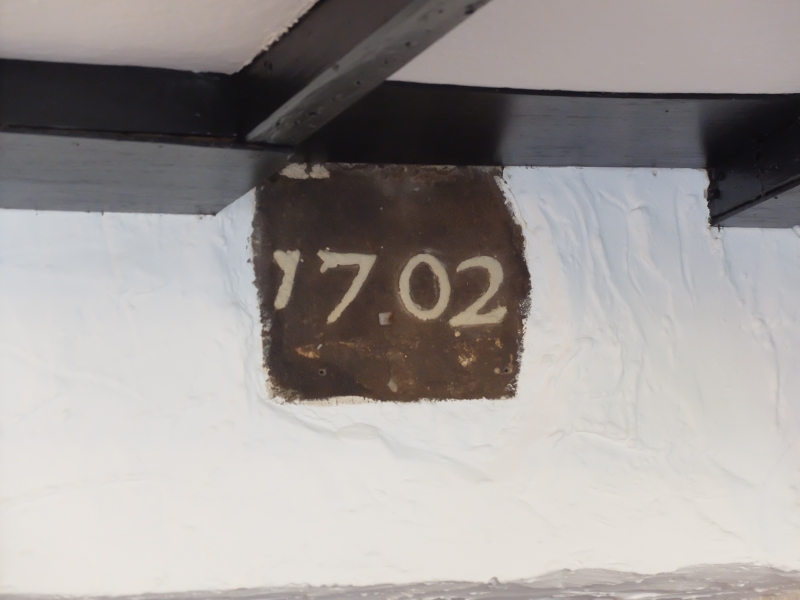
INTERIOR: only partially inspected (1999). Beamed ceiling to part of ground floor to central section; re-set stone inscribed '1702' to same section.
An altered terrace of late 18th/early 19th century cottages (possibly incorporating earlier fragments) built along the W side of the village green. In the valuation rolls for 1855-56 one of the central properties is listed as 'inn and land' and it would appear to have been in use as a public house/hotel since at least this time. The terrace appears more or less in its present form (minus 20th century additions) on the 1865 OS map.
External links are from the relevant listing authority and, where applicable, Wikidata. Wikidata IDs may be related buildings as well as this specific building. If you want to add or update a link, you will need to do so by editing the Wikidata entry.


Other nearby listed buildings
