Approximate Location Map
Large Map »
Latitude: 56.3879 / 56°23'16"N
Longitude: -4.2872 / 4°17'13"W
OS Eastings: 258891
OS Northings: 724080
OS Grid: NN588240
Mapcode National: GBR 0Y.1GTW
Mapcode Global: WH3LK.3PQV
Plus Code: 9C8Q9PQ7+44
Entry Name: Railway Viaduct, Ogle Burn, Lochearnhead
Listing Name: Lochearnhead, Former Railway Viaduct over the Ogle Burn
Listing Date: 14 May 1987
Category: B
Source: Historic Scotland
Source ID: 335398
Historic Scotland Designation Reference: LB4170
Building Class: Cultural
Also known as: Lochearnhead, Ogle Burn, Railway Viaduct
ID on this website: 200335398
Location: Comrie
County: Stirling
Electoral Ward: Trossachs and Teith
Parish: Comrie
Traditional County: Perthshire
Tagged with: Railway viaduct
Loch Lomond And Trossachs National Park Planning Authority
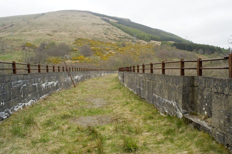
Crouch and Hogg, circa 1902-4. Curved, 9-arch concrete viaduct over the Ogle Burn. There are 7 40ft-span semicircular arches across the valley with half arches at each end. The concrete is channelled and there is a string course and coped parapet. The S parapet is corbelled out over each pier to form a refuge. The viaduct is a good and imposing example of concrete engineering.
Materials: Concrete
This viaduct is also called Ogle Burn Viaduct and is situated on the Northern edge of Lochearnhead. It was built as part of the Lochearnhead, St Fillans and Comrie Railway that ran between Balquhidder Station and Comrie and was absorbed by the Caledonian Railway in 1902, before it opened. This section of line was opened in 1904 and the final section to Balquhidder Station opened in May 1905. The viaduct at Edinchip over the Kendrum Burn is on the same line and similar in design, but has fewer arches and is on a less impressive curve.
The line was completely closed in 1951.
External links are from the relevant listing authority and, where applicable, Wikidata. Wikidata IDs may be related buildings as well as this specific building. If you want to add or update a link, you will need to do so by editing the Wikidata entry.


Other nearby listed buildings
