Approximate Location Map
Large Map »
Latitude: 56.5639 / 56°33'50"N
Longitude: -3.5853 / 3°35'6"W
OS Eastings: 302675
OS Northings: 742453
OS Grid: NO026424
Mapcode National: GBR V2.RJZ1
Mapcode Global: WH5NC.W8XW
Plus Code: 9C8RHC77+HV
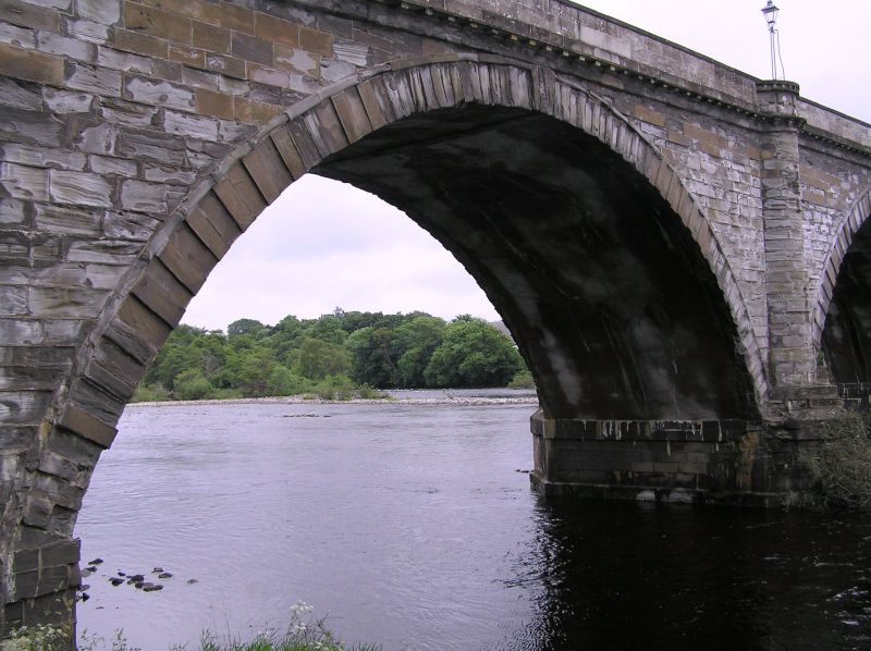
Entry Name: Dunkeld Bridge, River Tay, Bridge Street, Dunkeld
Listing Name: Dunkeld Bridge over River Tay.
Listing Date: 5 October 1971
Category: A
Source: Historic Scotland
Source ID: 337103
Historic Scotland Designation Reference: LB5620
Building Class: Cultural
Also known as: Dunkeld, Bridge Street, River Tay, Dunkeld Bridge
ID on this website: 200337103
Location: Dunkeld and Dowally
County: Perth and Kinross
Electoral Ward: Strathtay
Parish: Dunkeld And Dowally
Traditional County: Perthshire
Tagged with: Road bridge
685' long, 7 segmental arches, centre of 90 span, 2 of 84,
2 of 74 and 2 land arches of 90. Ashlar, dated 1809. T.
Telford, eng. 1805-09.
Part in Little Dunkeld Parish.
External links are from the relevant listing authority and, where applicable, Wikidata. Wikidata IDs may be related buildings as well as this specific building. If you want to add or update a link, you will need to do so by editing the Wikidata entry.


Other nearby listed buildings
