Approximate Location Map
Large Map »
Latitude: 55.7263 / 55°43'34"N
Longitude: -3.8118 / 3°48'42"W
OS Eastings: 286303
OS Northings: 649582
OS Grid: NS863495
Mapcode National: GBR 12T7.J4
Mapcode Global: WH5SB.FB2J
Plus Code: 9C7RP5GQ+G7
Entry Name: Birkfield, Boghall Road, Carluke
Listing Name: Boghall Road, Birkfield
Listing Date: 21 May 1991
Category: B
Source: Historic Scotland
Source ID: 338051
Historic Scotland Designation Reference: LB6459
Building Class: Cultural
ID on this website: 200338051
Location: Carluke
County: South Lanarkshire
Electoral Ward: Clydesdale West
Parish: Carluke
Traditional County: Lanarkshire
Tagged with: Architectural structure
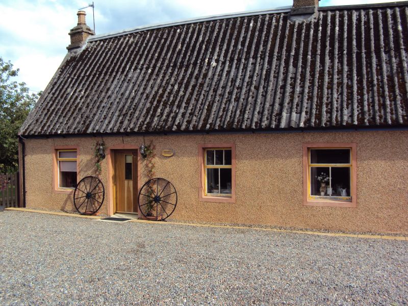
Mid/late 18th century in origin with later additions amd alterations. Single storey cottage arranged 3 and 2 bays (see NOTES) retaining original thatch beneath corrugated asbestos sheeting carried on raised brick eaves course. Front and NE gable harled with concrete margins. Rear and SW gable whitewashed rubble with diaginally droved ashlar dressings. Harled flat-roofed modern additions to SW gable and at rear. Predominently T-shaped glazing with top-hopper. 2 harled and corniced end stacks and 1 ridge stack to right of centre, with thackstanes and decorative cans.
NW ELEVATION: to road, 3-bays to left with central door, windows flanking. Door to right blocked to form window, window to outer bay, wing adjpining gable.
REAR: harled addition projecting at centre, flanked by windows with ?secondary wooden lintel at left.
NE GABLE: tiny attic window off centre in gablehead.
Possibly originally a 3-bay cottage and workshop, hence the off-centre stack, or a pair of terraced cottages, and may have been associated with the lime quarry to the E which was disused by 1864 (see 1st edition OS map). One of the few surviving examples of thatched buildings in Clydesdale, most of which retain their thatch beneath secondary coverings. Other examples include Douglashall, Carluke Parish, thatched building at Duinsyre Road, Newbigging, Biggar Parish and 35 Chapel Street, Carluke, all listed separately.
Upgraded, Category C(S) to B, 4 February 1998.
External links are from the relevant listing authority and, where applicable, Wikidata. Wikidata IDs may be related buildings as well as this specific building. If you want to add or update a link, you will need to do so by editing the Wikidata entry.


Other nearby listed buildings
