Approximate Location Map
Large Map »
Latitude: 55.7482 / 55°44'53"N
Longitude: -3.4487 / 3°26'55"W
OS Eastings: 309162
OS Northings: 651490
OS Grid: NT091514
Mapcode National: GBR 41CZ.57
Mapcode Global: WH6TG.0S26
Plus Code: 9C7RPHX2+7G
Entry Name: Medwynhead
Listing Name: Medwynhead House
Listing Date: 1 March 1978
Category: C
Source: Historic Scotland
Source ID: 340476
Historic Scotland Designation Reference: LB8366
Building Class: Cultural
ID on this website: 200340476
Location: West Linton
County: Scottish Borders
Electoral Ward: Tweeddale West
Parish: West Linton
Traditional County: Peeblesshire
Tagged with: Farmstead
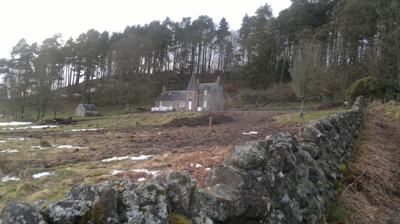
Dated 1797; remodelled early 20th century for Sir George Henry Sutherland (see Notes). Single-storey and attic, 5-bay, rectangular-plan house with advanced square-plan, pyramidal-capped tower with roundel window over door and cast-iron thistle finial at apex. Pale, roughly squared and snecked sandstone rubble with red sandstone margins. Crow-stepped dormer breaking eaves to far right. Lintel over door to left inscribed 'W L' and dated 1797.
12-pane glazing pattern to timber sash and case windows. Grey slate. Gable end stacks with clay cans. Cast-iron rainwater goods. Small gabled outbuilding to W; rubble with slate roof.
A late 18th century farmhouse with early 20th century Barional additions to form a picturesque summer residence, set among an outcrop of trees in remote Pentland Hill setting. The estates of Medwynhead and nearby North Slipperfield were purchased by Sir George Henry Sutherland in 1919 and the tower and dormer additions to the house date to around that time. The introduction of red sandstone margins to the tower and crowstep dormer echo the Highland Sutherland Estate style, adding to its interest.
The former farmstead, noted as 'Medwinhead' on the 1st Edition Ordnance Survey map of 1858, shows one roofed building on the site of the present house and a small group denoted as 'ruins'. During the later part of the 19th century, a James and Eleanor Faed occupied the farmstead. Fragmentary remains of earlier buildings on the site are still in evidence.
List description updated at resurvey (2010).
External links are from the relevant listing authority and, where applicable, Wikidata. Wikidata IDs may be related buildings as well as this specific building. If you want to add or update a link, you will need to do so by editing the Wikidata entry.


Other nearby listed buildings
