Approximate Location Map
Large Map »
Latitude: 56.0095 / 56°0'34"N
Longitude: -3.3936 / 3°23'36"W
OS Eastings: 313205
OS Northings: 680493
OS Grid: NT132804
Mapcode National: GBR 20.TKJG
Mapcode Global: WH6S9.V66W
Plus Code: 9C8R2J54+QH
Entry Name: 10 Post Office Lane, North Queensferry
Listing Name: North Queensferry, 10 Post Office Lane
Listing Date: 19 December 1979
Category: C
Source: Historic Scotland
Source ID: 342387
Historic Scotland Designation Reference: LB9990
Building Class: Cultural
ID on this website: 200342387
Location: Inverkeithing
County: Fife
Electoral Ward: Inverkeithing and Dalgety Bay
Parish: Inverkeithing
Traditional County: Fife
Tagged with: House
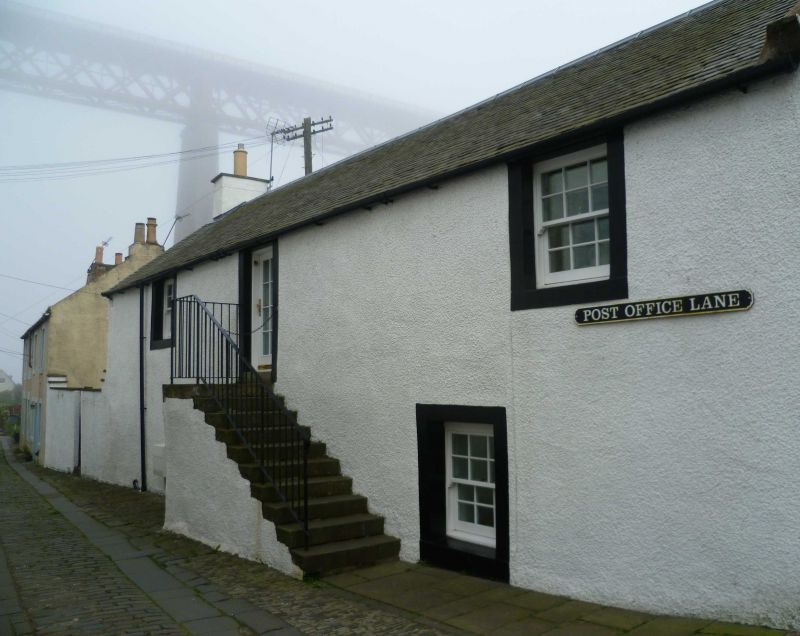
Dated 1776. 2-storey, 3-bay square-plan traditional house with modern 2-storey extension and conservatory to rear. Painted harling; droved stone margins.
N (PRINCIPAL) ELEVATION: symmetrical elevation. Central door, narrow fanlight above; surmounted by marriage inscription '17 I M/ M M 76'; flanked by windows. 1st floor windows to outer bays.
W ELEVATION: plain gable.
S ELEVATION: modern ground floor lean-to conservatory to left. 2-storey flat-roofed concrete extension to centre. 1st floor window to left close to eaves.
E ELEVATION: advanced gable of former attached house. Ground floor modern French door to right and elongated window to right.
4-pane timber sash and case windows to N and 1st floor to S; modern glazing elsewhere. Timber panelled and 2-pane glazed door to N. Pitched roof; pantiles; easing slates; raised ashlar coped skews; coped gablehead stacks; octagonal clay cans.
The house formerly abutting to E is now demolished. The traditional marriage inscription and pantiles add interest to an early village street plan. This house forms part of an 18th century arrangement of single and multi-storey dwellings forming large U-plan from No 4 Post Office Lane to No 1 Helen Place (formerly known as Chapel Place). Post Office Lane was formerly known as North Lane and was the main route down to the shore of St James's Bay, now mostly in-filled from quarrying.
External links are from the relevant listing authority and, where applicable, Wikidata. Wikidata IDs may be related buildings as well as this specific building. If you want to add or update a link, you will need to do so by editing the Wikidata entry.


Other nearby listed buildings
