Approximate Location Map
Large Map »
Latitude: 56.4892 / 56°29'21"N
Longitude: -3.1036 / 3°6'13"W
OS Eastings: 332139
OS Northings: 733556
OS Grid: NO321335
Mapcode National: GBR VG.K30Q
Mapcode Global: WH6Q4.95B4
Plus Code: 9C8RFVQW+MH
Entry Name: School, Fowlis
Listing Name: Former School Including Playshed Wcs Boundary Wall and Railings
Listing Date: 26 August 1992
Category: B
Source: Historic Scotland
Source ID: 345829
Historic Scotland Designation Reference: LB12894
Building Class: Cultural
ID on this website: 200345829
Location: Fowlis Easter
County: Angus
Electoral Ward: Monifieth and Sidlaw
Parish: Fowlis Easter
Traditional County: Perthshire
Tagged with: School building
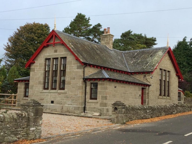
Earlier-mid 19th century, raises and extended 1888. Single storey, rectangular-plan school, made T-plan by addition of classroom 1 to 5, with lower cloakroom blocks in re-entrants. Original building stugged rubble; additions stugged and snecked rubble, stugged and margined quoins; slate roof. Base course to additions; sash and case windows, 4- over 6-pane to classroom tripartites, 2- over 4-pane to cleakroom singles, stugged and margined dressings with chamfered cills; deep eaves with exposed purlin and rafter ends, moulded bargeboards, kingpost and collar exposed at S gable, small ball finials with elongated pinnacles; corniced stacks. E ELEVATION: gable to right (modified original building), tripartite window; door to bay at left re-entrant; door to lean-to to far right. W ELEVATION: mirror image of E elevation.
S GABLE: gable to centre, tripartite window; single window to lower, slightly recessed flanking bays.
N GABLE: full-width lean-to, central stack rising through eaves to main wall.
INTERIOR: boarded dado; original chimneypieces.
PLAYSHED: timber playshed with corrugated pentice roof.
WC'S: small rubble-built wc block to W of playshed.
BOUNDARY WALL AND RAILINGS: rubble boundary wall to W (N boundary wall constructed 1980s), cast-iron and steel fence to E.
A school is mentioned in the OLD STATISTICAL ACCOUNT and is shown in its present position on the 1799 and 1861 maps. The south gable is dated 1888 above the tripartite window. The adjacent former schoolhouse is dated 1855, and a datestone (1827) is built into a modern wall to its east. The earliest part of the present building therefore is likely to date from either 1827 or 1855.
External links are from the relevant listing authority and, where applicable, Wikidata. Wikidata IDs may be related buildings as well as this specific building. If you want to add or update a link, you will need to do so by editing the Wikidata entry.


Other nearby listed buildings
