Approximate Location Map
Large Map »
Latitude: 55.6038 / 55°36'13"N
Longitude: -2.6756 / 2°40'32"W
OS Eastings: 357530
OS Northings: 634668
OS Grid: NT575346
Mapcode National: GBR 93RN.J1
Mapcode Global: WH7WQ.WD2X
Plus Code: 9C7VJ83F+GQ
Entry Name: Old Bridge, Drygrange
Listing Name: Drygrange Old Bridge
Listing Date: 16 March 1971
Category: A
Source: Historic Scotland
Source ID: 348631
Historic Scotland Designation Reference: LB15106
Building Class: Cultural
Also known as: Drygrange Old Bridge
ID on this website: 200348631
Location: Melrose
County: Scottish Borders
Electoral Ward: Leaderdale and Melrose
Parish: Melrose
Traditional County: Roxburghshire
Tagged with: Arch bridge Road bridge
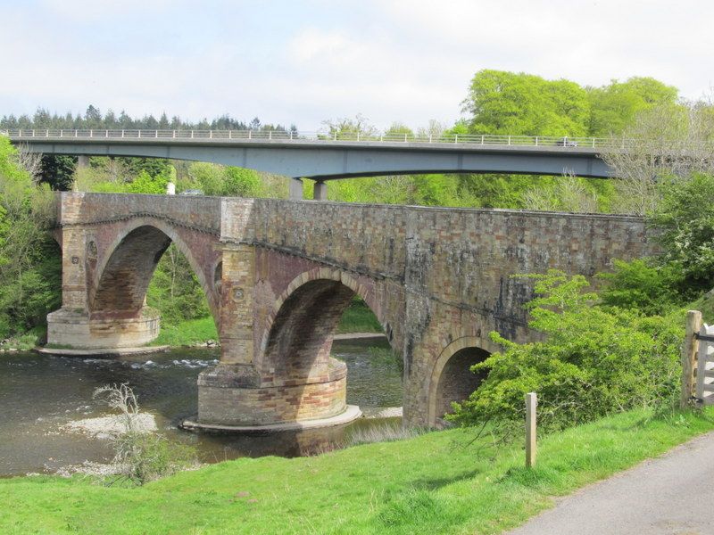
Alexander Stevens Snr, 1778-80. Late 18th century road bridge with 105ft wide central segmental archway flanked by round arches of 55ft, crossing the River Tweed. Smaller accommodation arch to south abutment. Red sandstone to spandrels; red and buff sandstone to parapet and foundations; narrow coursed whinstone to decorative panels. Rough-hewn pier foundations tied with iron cramps support curved and pointed cutwaters to central arch. Recessed circular panels with urn ornaments to spandrel faces. Dentilated string course. Triangular supporting piers enriched with quatrefoil medallions and terminating in angled refuges at road level. Coped parapet with pyramidal finials at either approach.
An exceptional, finely engineered and well-detailed road bridge of 1778 crossing the River Tweed at Leaderfoot. Elegantly proportioned, the crown of its broad central arch is less than 3ft thick. Longitudinal cavities within each spandrel are designed to reduce the weight of the structure. The use of prow-like cutwaters was also very new to Britain in 1780 and this is one of the first examples. The recessed roundels within the spandrels with carved urn ornaments provide additional character. The dentilled string course marks the level of the original roadway which was raised toward the ends at a later date to make the carriageway more level. The bridge remains an outstanding example of late 18th century bridge engineering.
Alexander Stevens was a renowned Scottish architect and engineer who specialised in Bridge building. 'The Buildings of Scotland' notes that the innovative use of French-style curved and pointed cutwaters were probably inspired by Robert Mylne's Blackfriars Bridge in London (1760-69). They also feature in Stevens's later design for Teviot Bridge in Kelso (see separate listing).
Drygrange Old Bridge carried the A68 trunk road traffic until 1974 when it was bypassed by a prefabricated box-girder bridge by Sir Alexander Gibb and Partners. A short distance upstream stands the towering, 126ft high Leaderfoot Railway Viaduct of 1865 (see separate listing). Together, these three intervisible bridges reflect changing approaches to bridge engineering over a two century period.
Old Drygrange Bridge is sometimes referred to as the 'Fly Boat' bridge in reference to an earlier ferry crossing at Leaderfoot.
List description updated at resurvey (2010).
External links are from the relevant listing authority and, where applicable, Wikidata. Wikidata IDs may be related buildings as well as this specific building. If you want to add or update a link, you will need to do so by editing the Wikidata entry.


Other nearby listed buildings
