Approximate Location Map
Large Map »
Latitude: 54.8578 / 54°51'27"N
Longitude: -4.0392 / 4°2'20"W
OS Eastings: 269200
OS Northings: 553347
OS Grid: NX692533
Mapcode National: GBR 0D78.BF
Mapcode Global: WH4WB.X5R9
Plus Code: 9C6QVX56+48
Entry Name: Tongland Bridge
Listing Name: Tongland Bridge
Listing Date: 4 November 1971
Category: A
Source: Historic Scotland
Source ID: 350983
Historic Scotland Designation Reference: LB17125
Building Class: Cultural
ID on this website: 200350983
Location: Tongland
County: Dumfries and Galloway
Electoral Ward: Dee and Glenkens
Parish: Tongland
Tagged with: Road bridge
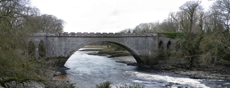
Built 1804-1808. The bridge is usually credited to Thomas Telford but there is evidence that Alexander Naysmith collaborated with the design. Main segmental central arch 110ft span approx, flanked by round full-height buttress towers with 3 narrow pointed arches each side.
Bull-faced granite masonry, arches with boldly rusticated voussoirs. Corbelled embattled parapet, buttresses serve as pedestrian refuges, splayed abutments and parapet.
De- scheduled 5 March 1996.
External links are from the relevant listing authority and, where applicable, Wikidata. Wikidata IDs may be related buildings as well as this specific building. If you want to add or update a link, you will need to do so by editing the Wikidata entry.


Other nearby listed buildings
