Approximate Location Map
Large Map »
Latitude: 58.2099 / 58°12'35"N
Longitude: -6.3919 / 6°23'30"W
OS Eastings: 142121
OS Northings: 932975
OS Grid: NB421329
Mapcode National: GBR B7L0.YVV
Mapcode Global: WGY2Y.SXF3
Plus Code: 9CCM6J55+W6
Entry Name: Sea Wall And Tower, Lews Castle, Stornoway, Lewis
Listing Name: Lews Castle, Lodges, Boundary Walls, Sea Walls and Tower Near Stornoway Harbour Including Cuddy Point
Listing Date: 25 March 1971
Category: A
Source: Historic Scotland
Source ID: 353507
Historic Scotland Designation Reference: LB19206
Building Class: Cultural
ID on this website: 200353507
Location: Stornoway
County: Na h-Eileanan Siar
Electoral Ward: Steòrnabhagh a Deas
Parish: Stornoway
Tagged with: Architectural structure
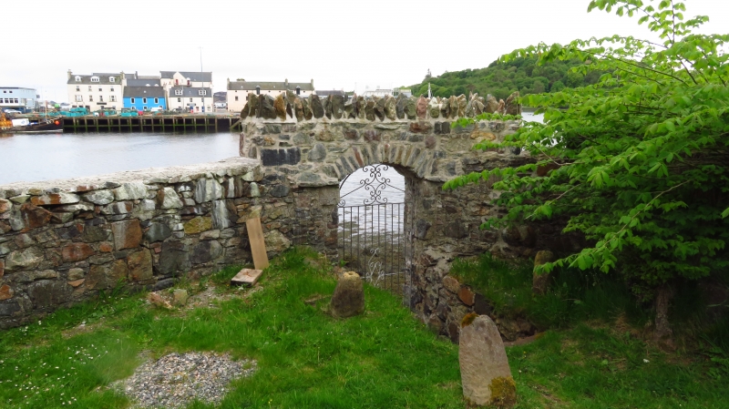
Extensive series of bounary walls/sea walls bounding policies of Lews Castle (Lady Lever Park) and providing a driveway along the sea front; likely to date mostly from circa 1845 onwards (in which year Matheson began work in Lewis), and probably (in substantial measure, at least) involved the architect Charles Wilson in their design; he was most likely involved too with design of the LODGE, at the seagate opposite Stornoway Harbour. Walls at CUDDY POINT built 1868 in a separate phase of building (Wilson dies 1863).
LODGE: single storey, 3-bay T-plan front facing the town, doorway formerly in both re-entrant angles of centre gable (so it may originally have been a double cottage); doorway at left now blocked, survivor in right hand side (panelled door, fanlight); gabled slate roofs; furtherrange to rear in twin-gabled south flank elevation, canted ground floor window at left. Neo-Jacobean fireclay finials over gable heads. WALLS: are rubble-built, including crenellations and intermittent, slightly taller and projecting turrets; larger square tower terminates wall at north, and har altered/added top storey in timber; square-plan, a dummy tower house with crenellated parapet, rock-faced and raises quoins; entrance at left hand side of west wall.
At CUDDY POINT, a large flat area has been formed on a base of natural reef; this extension to the original scheme commemorated by an inscription panel "This wall at Cuddy Point is erected by me Anne Mary Perceval as a memento of deer(sic) love and gratitude to the best of sons-in-law Sir James Matheson Bart MP in commemoration of the anniversary of his silver-wedding-day kept at Lews Castle Nov 19th 1868". At the north end is a slipway with pair steel cran-hoists for lifeboat; modern shed at head of slip. Brick-corbelled bartizans.
External links are from the relevant listing authority and, where applicable, Wikidata. Wikidata IDs may be related buildings as well as this specific building. If you want to add or update a link, you will need to do so by editing the Wikidata entry.


Other nearby listed buildings
