Approximate Location Map
Large Map »
Latitude: 54.9656 / 54°57'56"N
Longitude: -4.4823 / 4°28'56"W
OS Eastings: 241183
OS Northings: 566256
OS Grid: NX411662
Mapcode National: GBR 4H.Y687
Mapcode Global: WH3TF.3GT5
Plus Code: 9C6QXG89+63
Entry Name: The Schoolhouse, Stewart Of Garlies, Minnigaff
Listing Name: Minnigaff, the Old Schoolhouse and Boundary Walls
Listing Date: 3 August 1993
Category: C
Source: Historic Scotland
Source ID: 353632
Historic Scotland Designation Reference: LB19303
Building Class: Cultural
ID on this website: 200353632
Location: Minnigaff
County: Dumfries and Galloway
Electoral Ward: Mid Galloway and Wigtown West
Parish: Minnigaff
Traditional County: Kirkcudbrightshire
Tagged with: Architectural structure
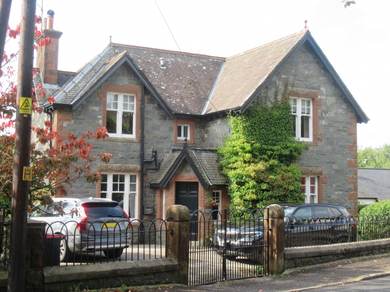
Circa 1900. 2-storey former school house. Whin rubble, squared and snecked to E elevation. Red sandstone bull-faced dressings. Long and short quoins. Smooth margin drafts and angle margins. Chamfered cills. Overhanging eaves.
E (MILLCROFT ROAD) ELEVATION: gable advanced to right; gabled bay to left; porch at centre set in re-entrant angle. Canted porch; timber-finialled gable over panelled door to SE; window to flanking faces. Small 2-light window above at 1st floor. 3-light window at ground floor and 2-light window at 1st floor to outer bays.
S ELEVATION: gabled bay at centre. Window to left at ground and 1st floors. small at 1st floor.
N ELEVATION: gabled bay at centre. Window at centre at ground floor.
W ELEVATION: piended bay to left; window at ground and 1st floors. Piended wing advanced at centre; boarded door to left and small window to right at ground floor to left return; window to right at 1st floor to W; window at centre at ground floor to right return. Single storey piended outbuilding adjoined to corner to left.
Sash and case windows, with small-pane upper sashes and plate glass lower sashes. Corniced red sandstone ashlar stacks, gablehead to N and S, wallhead to wing to W. Small grey slates. Red ridge tiles; several ball finials. Low rubble wall; concrete saddleback-coping. Small red sandstone gatepiers. Hooped railings and gates.
The Old School House is not shown on the OS Map of 1894; it is shown
on the OS Map of 1907. The Old School House is situated to the N of the former school, which is now used as a Youth Hostel (see separate listing).
External links are from the relevant listing authority and, where applicable, Wikidata. Wikidata IDs may be related buildings as well as this specific building. If you want to add or update a link, you will need to do so by editing the Wikidata entry.


Other nearby listed buildings
