Approximate Location Map
Large Map »
Latitude: 56.2919 / 56°17'30"N
Longitude: -3.2326 / 3°13'57"W
OS Eastings: 323802
OS Northings: 711734
OS Grid: NO238117
Mapcode National: GBR 26.7KQX
Mapcode Global: WH6R1.93XW
Plus Code: 9C8R7QR8+QX
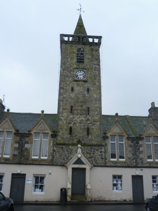
Entry Name: Town Hall, 30 High Street, Auchtermuchty
Listing Name: Auchtermuchty Town House and Council Chambers, High Street
Listing Date: 18 August 1972
Category: B
Source: Historic Scotland
Source ID: 356647
Historic Scotland Designation Reference: LB21372
Building Class: Cultural
ID on this website: 200356647
Location: Auchtermuchty
County: Fife
Town: Auchtermuchty
Electoral Ward: Howe of Fife and Tay Coast
Traditional County: Fife
Tagged with: City hall Seat of local government
Dated 1728. 2-storey, central tower with slit windows,
round arched belfry stage (1 opening each face), balustraded
parapet and stone pyramid spire. Victorian alterations,
1st floor windows altered to bipartites with gable dormer
heads, clock 1897. Rubble, crowstepped, slated roof.
Scheduled Monument. De-scheduled 5 October 1998.
External links are from the relevant listing authority and, where applicable, Wikidata. Wikidata IDs may be related buildings as well as this specific building. If you want to add or update a link, you will need to do so by editing the Wikidata entry.


Other nearby listed buildings
