Approximate Location Map
Large Map »
Latitude: 55.4629 / 55°27'46"N
Longitude: -4.6287 / 4°37'43"W
OS Eastings: 233900
OS Northings: 621920
OS Grid: NS339219
Mapcode National: GBR 39.XYN2
Mapcode Global: WH2PP.WY1H
Plus Code: 9C7QF97C+4G
Entry Name: Auld Kirk Of Ayr, Kirk Port, Ayr
Listing Name: Kirk Port, Auld Kirk of Ayr, Church of Scotland
Listing Date: 5 February 1971
Category: A
Source: Historic Scotland
Source ID: 357040
Historic Scotland Designation Reference: LB21653
Building Class: Cultural
Also known as: Ayr, Kirk Port, Auld Kirk Of Ayr
ID on this website: 200357040
Location: Ayr
County: South Ayrshire
Town: Ayr
Electoral Ward: Ayr West
Traditional County: Ayrshire
Tagged with: Church building Gothic architecture Architectural structure
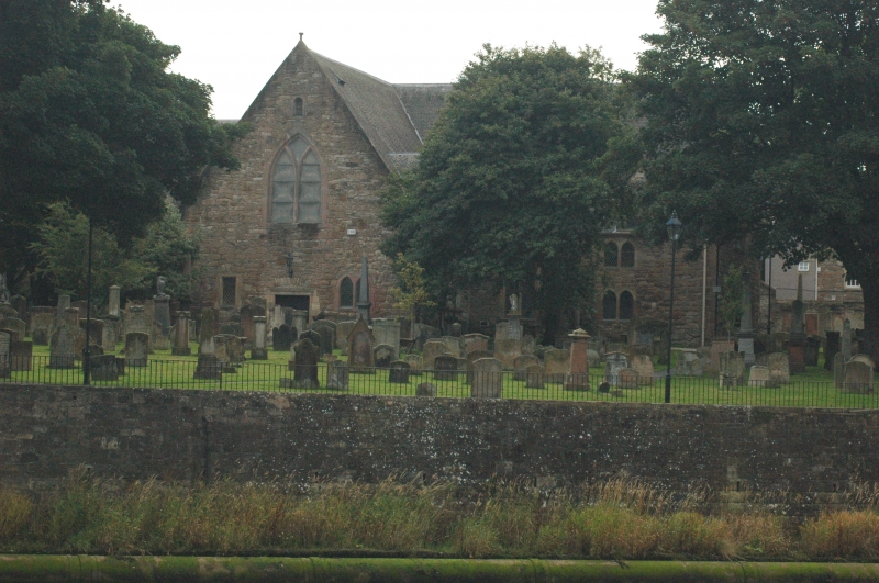
Theophilius Rankeine, 1652-4, 1836 alterations by David Bryce (including replacement ceiling, dormers renewed and doubled in number), general renovation 1864, refurnished 1887, addition and alterations 1933, general renovation 1952. Single storey with attic, originally T-plan, now cruciform (S arm addition) gabled church with gothic detailing. Sandstone rubble; stugged, squared and snecked sandstone to S arm. Cornice; finials; roll-moulded pointed arch openings.
NORTH ARM. N (ENTRANCE) ELEVATION: central roll-moulded square-headed entrance; 2-leaf timber door; lantern above relieving arch; pair of leaded lights flanking; cusped tracery window to gablehead; narrow louvred window above. W ELEVATION: 2 pairs of leaded lights to left; tracery window to right. 2 gabled dormers at attic; tracery windows. Memorial stones to wall. E ELEVATION: reverse of North Arm, W elevation. Memorial to the Rev William Adair at centre.
WEST ARM. W (ENTRANCE) ELEVATION: as for North Arm, N elevation. Stained glass to pair of lights to left. N ELEVATION: 2 pairs of leaded lights at centre. 2 gabled dormers at attic; tracery windows. Memorial stone to wall. S ELEVATION: as for North Arm, W elevation. Timber door to outer left.
SOUTH ARM. S ELEVATION: single tracery window to gablehead; splayed transom. E ELEVATION: 3 square-headed leaded windows. W ELEVATION: timber door to left; letterbox fanlight; recessed panel above; flanking square-headed leaded windows.
EAST ARM. E (ENTRANCE) ELEVATION: as for North Arm, N elevation. Single leaded window only to left; stained glass to windows to right; no cusping to tracery of gable window. N ELEVATION: 2 dormers at attic. Infilled single window right of centre. Memorial stones to wall. S ELEVATION: as for N arm, E elevation. Stained glass to lower pair of windows.
Leaded and stained glass windows. Grey slate roof; stone skews; skewputts (to N elevation dated 1654).
INTERIOR: T-plan. Timber roof, pews, (box pew to E) and church furniture (predominantly late 19th century), bow-fronted panelled pulpit with sounding board (rebuilt). 3 galleries on turned timber columns; colonnettes to arcaded, panelled fronts; pendants to arches; niche frieze; Trades' Gallery to W; Merchant's Gallery to N; Sailor's Gallery to E (model of the ship 'Arethusa' hangs from ceiling). Fragment of original pulpit, removed 1887, restored 1952.
Ecclesiastical building in use as such (see separate list descriptions for gateway and graveyard including boundary walls and lamp standard). In 1652, Oliver Cromwell established a fortress in Ayr. This strategic defence commanded Ayr harbour and shore line. Unfortunately for the citizens of Ayr, the citadel walls enclosed the mediaeval church of St John the Baptist, the only place of worship in the burgh of Ayr, now seized for use as a military barracks. Under Cromwell, Colonel Alured donated 1,000 Merks from Commonwealth funds towards a new church, and this document can be seen displayed in the church interior. The new Parish Church was built in the heart of Ayr, on the site of the monastery, chapel and gardens occupied by the Franciscan Order from 1474 until 1560, which had not been redeveloped. Of note within the church and a common feature of the post-Reformation period, but with many now sadly destroyed, is the black and gold Benefaction Board, renewed circa 1792 recording the gift in 1708 of ?100 for the poor of the parish from an Alderman Smithe of Londonderry. Within the interior, there also existed a small semi-circular Magistrates' Gallery, between the
Sailor's and the Merchants' Galleries. That, and an exterior stair to the E arm, N elevation, leading to this Gallery have now been destroyed.
External links are from the relevant listing authority and, where applicable, Wikidata. Wikidata IDs may be related buildings as well as this specific building. If you want to add or update a link, you will need to do so by editing the Wikidata entry.


Other nearby listed buildings
