Approximate Location Map
Large Map »
Latitude: 56.0181 / 56°1'5"N
Longitude: -3.6088 / 3°36'31"W
OS Eastings: 299812
OS Northings: 681748
OS Grid: NS998817
Mapcode National: GBR 1R.SZ2Z
Mapcode Global: WH5QW.JZRS
Plus Code: 9C8R299R+7F
Entry Name: West Pier Tavern, Scotland's Close, Bo'Ness
Listing Name: Scotland's Close, Bo'ness Public Library, Former Old West Pier Tavern
Listing Date: 25 November 1980
Category: B
Source: Historic Scotland
Source ID: 357945
Historic Scotland Designation Reference: LB22388
Building Class: Cultural
ID on this website: 200357945
Location: Bo'Ness
County: Falkirk
Town: Bo'Ness
Electoral Ward: Bo'ness and Blackness
Traditional County: West Lothian
Tagged with: Architectural structure
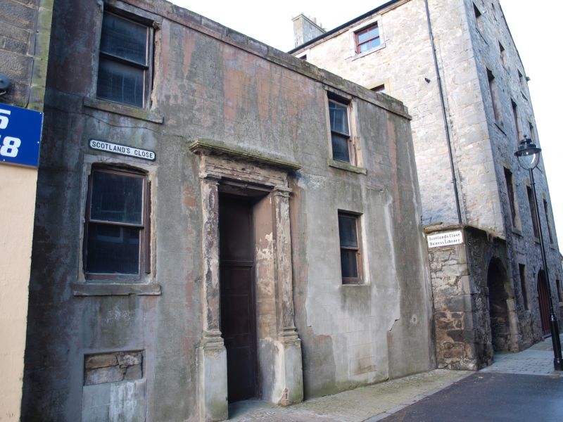
Dated 1711, probably incorporating earlier fabric with many later alterations, N gable remodelled early 19th century, extended to W and S and converted to library 1978-80 by Falkirk District Council. 2-storey, 4-bay former tavern on corner site. Rubble with raised margins and quoin strips. 1st floor cill course and moulded eaves course.
N (WAGGON ROAD) ELEVATION: gabled elevation with pilastered and pedimented doorpiece off-centre right at ground, windows in flanking bays (that to right abutting doorpiece) and 2 larger windows to 1st floor. Modern extension adjoining at outer right.
E (SCOTLAND'S CLOSE) ELEVATION: ground floor with boarded timber door to right of centre at ground, 2 windows in bays to right and further timber-louvered opening to outer left beyond timber forestair leading to 1st floor timber door with lintel inscribed '17 FMG MR 11' to left of centre and windows in flanking bays and further window to outer right.
S ELEVATION: gabled elevation with low modern extension projecting to left; remnants of early-mid 18th century chimney piece with massive lintel supported on rounded corbel and small aumbry (probably salt box) immediately to left at ground and roll-moulded chimneypiece to 1st floor from demolished house to S.
W (WAGGON ROAD) ELEVATION: slated rubble elevation of 1978-80 extension.
12-pane glazing pattern in replacement timber sash and case windows. Modern pantiles with slate eaves easing course. Coped margined squared rubble stacks with cans to N. Flat ashlar-coped skew with scroll skewputts to N, crowstepped gable to S.
INTERIOR: some panelling to 1st floor rooms with fine plasterwork ceiling, cornice and buffet niche, and carved chimney fire surround.
Formerly listed as the 'Old West Pier Tavern' and dated 1711, but stylistically the S elevation chimneypieces suggest a 17th century date. Alterations during the early 19th century would have included the north gable addition of straight skews, skewputts and large windows. During the 1978 renovation the building was extended into the ground floor of the separately listed warehouse at Nos 37-49 Scotland's Close. The West Pier Tavern, now Bo'ness Library, was strategically sited alongside the harbour and nearby warehouses, with the category 'A' listed Dymock's Building (47-51 North Street) immediately opposite.
External links are from the relevant listing authority and, where applicable, Wikidata. Wikidata IDs may be related buildings as well as this specific building. If you want to add or update a link, you will need to do so by editing the Wikidata entry.


Other nearby listed buildings
