Approximate Location Map
Large Map »
Latitude: 55.8977 / 55°53'51"N
Longitude: -3.066 / 3°3'57"W
OS Eastings: 333437
OS Northings: 667689
OS Grid: NT334676
Mapcode National: GBR 7017.0P
Mapcode Global: WH6T1.W152
Plus Code: 9C7RVWXM+3H
Entry Name: Town Lodge, Duke's Gate, High Street, Dalkeith
Listing Name: High Street, Duke's Gate, Town Lodge and Estate Walls
Listing Date: 26 June 1971
Category: B
Source: Historic Scotland
Source ID: 360293
Historic Scotland Designation Reference: LB24376
Building Class: Cultural
ID on this website: 200360293
Location: Dalkeith
County: Midlothian
Town: Dalkeith
Electoral Ward: Dalkeith
Traditional County: Midlothian
Tagged with: Lodge
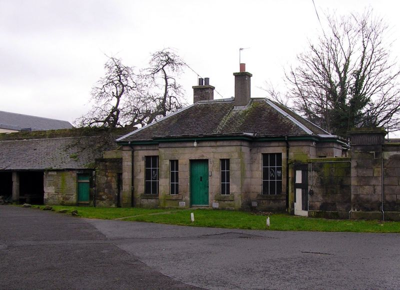
DUKE'S GATE: James Playfair, 1784. Gateway to Dalkeith Estate from High Street. 4 square piers linked by screen wall, gateway at centre. Ashlar. Base course. Fluted frieze, cornice and blocking course to piers; surmounted by iron tripod lamp bases. 2-leaf cast-iron gates, arch-in-grid and spearheaded. Lower walls flanking outer piers, curved to S, each with pedestrian gate. Adjoined to lodge to E.
TOWN LODGE: earlier-mid 19th century, extended and re-roofed later in century. Single storey, 3-bay lodge. Ashlar. Base course. String course below eaves level to form blocking course. Timber eaves course. Broad raised cills. Pebble-dashed extension.
N (PRINCIPAL, POLICIES) ELEVATION: centre bay advanced and flat-roofed; boarded door at centre, narrow windows flanking. Window in bays to left and right. Screen wall of gates adjoined to right.
W (HIGH STREET) ELEVATION: flat-roofed advanced panel to left, with bipartite window and narrow windows on return. Pebble-dashed extension to right with window and small window flanking to right.
Variously sized small-pane glazing patterns in sash and case windows. Grey slates to piend and platform roof. Harled stacks below ridge to N and E pitches.
Rubble wall with garden door adjoined to right to E. Lean-to rubble cartshed to left, adjoined to rubble wall on EW axis. Boundary wall running S adjoined to left to S.
ESTATE WALLS: sandstone rubble, semicircular coped. Running S from S elevation of Lodge, following corner of Musselburgh Road, incorporating 1 and 3 Musselburgh Road (see separate listing) and around Estate. Rubble coped wall to left of Lodge, within estate, running E to meet main policy wall.
Entrance to Dalkeith Palace and Park. The Estate wall is known as "The Duke's Dyke".
External links are from the relevant listing authority and, where applicable, Wikidata. Wikidata IDs may be related buildings as well as this specific building. If you want to add or update a link, you will need to do so by editing the Wikidata entry.


Other nearby listed buildings
