Approximate Location Map
Large Map »
Latitude: 55.895 / 55°53'42"N
Longitude: -3.0692 / 3°4'9"W
OS Eastings: 333231
OS Northings: 667396
OS Grid: NT332673
Mapcode National: GBR 7008.9M
Mapcode Global: WH6T1.T3N3
Plus Code: 9C7RVWWJ+28
Entry Name: 115 High Street, Dalkeith
Listing Name: 115 and 117 High Street, and 3-6 (Inclusive Nos) Brunton's Close
Listing Date: 30 June 1983
Category: C
Source: Historic Scotland
Source ID: 360318
Historic Scotland Designation Reference: LB24397
Building Class: Cultural
ID on this website: 200360318
Location: Dalkeith
County: Midlothian
Town: Dalkeith
Electoral Ward: Dalkeith
Traditional County: Midlothian
Tagged with: House
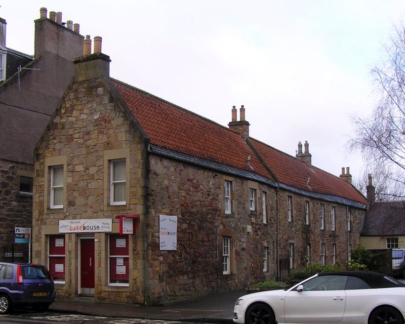
18th century, with later alterations; restored 1982. 2-storey gabled row of houses on E-W axis, divided into 3 sections. Rubble. Ashlar surrounds and quoins to E elvation, flush margins with squared tails to remaining elevations; some concrete replacements. Irregularly sized fenestration.
E (HIGH STREET) ELEVATION: gabled 2-bay. Door between 19th century shop windows at ground; window to left and right at 1st floor.
W ELEVATION: door and window at 1st floor to left of W elevation; rubble wall running W adjoined to left.
S ELEVATION: 4 doors and irregularly disposed fenestration. 2 pal stones on either side of entrance to No 6.
N ELEVATION: irregularly disposed fenestration to centre; mid 19th century cottage, No 119 High Street (see separate listing) running N attached to right, window at ground to outer right beyond cottage.
Largely sash and case windows, several fixed-pane with top hoppers; largely 12-pane glazing pattern, plate glass to E elevation. Steeply pitched roof with pantiles and slate easing course. Coped skews. Gablehead stacks to E and W, 2 brick ridge stacks.
The row, which was restored in 1982, follows the original burgh rigg pattern.
External links are from the relevant listing authority and, where applicable, Wikidata. Wikidata IDs may be related buildings as well as this specific building. If you want to add or update a link, you will need to do so by editing the Wikidata entry.


Other nearby listed buildings
