Approximate Location Map
Large Map »
Latitude: 56.4599 / 56°27'35"N
Longitude: -2.9605 / 2°57'37"W
OS Eastings: 340909
OS Northings: 730163
OS Grid: NO409301
Mapcode National: GBR ZC0.ZW
Mapcode Global: WH7RB.HWHN
Plus Code: 9C8VF25Q+XR
Entry Name: 24 Chandlers Lane, Dundee
Listing Name: 2-26 (even nos) Chandlers Lane and Patent Slip, Dundee
Listing Date: 2 November 1989
Last Amended: 1 June 2023
Category: A
Source: Historic Scotland
Source ID: 361075
Historic Scotland Designation Reference: LB24957
Building Class: Cultural
ID on this website: 200361075
Location: Dundee
County: Dundee
Town: Dundee
Electoral Ward: Maryfield
Traditional County: Angus
Tagged with: Architectural structure
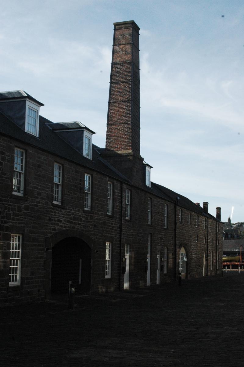
The principal (east) elevation along Chandlers Lane is 21-bays wide (15 bays, extended to the north by 6 bays around 1850). There is a tall, squared, brick-built chimney with wrought iron tie-bands rising from a rubble-built base. There are two segmental-arched cart-entrances, one now infilled with glazing (2023) and the other roughly central within the range. The north, bowed extension is three storeys high and within the same eaves-line. The rear (west) elevation has four wide elliptical-arched openings to the right of the central cart-entrance with ashlar voussoirs (now infilled with glazing). The former rectangular-plan openings to the rear of the 1850 north extension have been infilled with timber cladding and glazing.
The windows are replacements throughout, sash and case frames in a variety of sizes and in a mixture of multi-pane glazing patterns. The 1850 extension to the north has small square windows at first floor level. There are three chimneystacks, two wallhead and one apex.
The piended roof is covered in slates with replacement piended dormer windows, predominantly grouped in pairs. There are some single rooflights in both roof pitches of the north extension.
Low sea protection wall, rubble-built.
The patent slip was largely infilled from the mid-20th century and only a small section now remains, ashlar sides and paved with 21st century metal railings and pedestrian steps leading to ground level.
The site was redeveloped for housing in around 2006. The only surviving historic structures are the former warehouse range along Chandlers Lane and the eastern part of the patent slip, which now forms part of a residential courtyard. The patent slip (or marine railway) historically had a 15 hp steam engine which could haul vessels up to 800 tons in weight out of the water onto a slipway. The tidal harbour to the west was gradually infilled from the early 1960s onwards to make way for the Tay Road Bridge (opened 1966).
Statutory address and listed building record revised in 2023. Previously listed as 'MARINE PARADE, HARBOUR WORKSHOPS AND PATENT SLIP'.
External links are from the relevant listing authority and, where applicable, Wikidata. Wikidata IDs may be related buildings as well as this specific building. If you want to add or update a link, you will need to do so by editing the Wikidata entry.


Other nearby listed buildings
