Approximate Location Map
Large Map »
Latitude: 56.0697 / 56°4'10"N
Longitude: -3.4604 / 3°27'37"W
OS Eastings: 309182
OS Northings: 687280
OS Grid: NT091872
Mapcode National: GBR 1Y.PNJH
Mapcode Global: WH5QR.TPDR
Plus Code: 9C8R3G9Q+VR
Entry Name: 11 Abbey Park Place, Dunfermline
Listing Name: 11 Abbey Park Place
Listing Date: 12 January 1971
Category: B
Source: Historic Scotland
Source ID: 362464
Historic Scotland Designation Reference: LB25996
Building Class: Cultural
ID on this website: 200362464
Location: Dunfermline
County: Fife
Town: Dunfermline
Electoral Ward: Dunfermline Central
Traditional County: Fife
Tagged with: Architectural structure
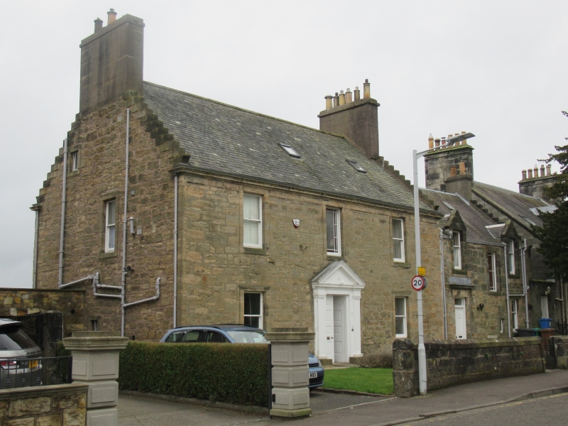
Late 18th century incorporating earlier fabric; alterations (particularly in later 19th century) and extension. House; comprising 2-storey with attic and basement 3-bay main block with single storey and attic extension (originally single storey) to W. Main block of simplified classical design; crowstepped gables to both blocks. Coursed dressed partially droved sandstone rubble; harled to rear (S) elevation. Sandstone ashlar dressings. Eaves band adjoining 1st floor cills and architraved windows to principal (N) and E elevations of main block.
N (PRINCIPAL) ELEVATION: central entrance to main block; 20th century pilastered and pedimented timber architrave and panelled timber door. Window above and flanking windows to ground and 1st floors. Vertical margin to either side. Extension set back slightly to right. Entrance with corniced architrave to left; replacement 2-leaf panelled timber door with rectangular fanlight. Window to outer right of ground floor; small window to left. Architraved stair window to centre above. Architraved gabled dormer to each of flanking outer bays.
S ELEVATION: central architraved entrance with late 20th century glazed door. Window above to 1st floor and attic; flanking windows to each floor; those to ground and 1st floors to left are later canted ones; that to ground floor to right has had narrow flanking lights inserted. Later piended windows to attic; those to outer bays are polygonal. Extension to left has been extended on this side. 2 windows to each floor; all except that to left of ground floor are canted.
E ELEVATION: steps down to architraved entrance to centre of basement. 2 small windows to left of ground floor. Window to centre of 1st floor. Small window to left of attic.
Mainly 2-pane timber sash and case windows. Grey slate roofs; beaked skewputts where gables crowstepped. Rendered gablehead stacks with band courses to either side (E and W) of main block; corniced gablehead stack to W of extension; round cans.
INTERIOR: retains early turnpike staicase with moulded risers between basement and ground floor.
A building, probably original block of house, appears on the site on John Wood's map. Retains fabric (at basement level, including staircase) which may be earlier than late 18th century.
External links are from the relevant listing authority and, where applicable, Wikidata. Wikidata IDs may be related buildings as well as this specific building. If you want to add or update a link, you will need to do so by editing the Wikidata entry.


Other nearby listed buildings
