Approximate Location Map
Large Map »
Latitude: 55.0686 / 55°4'6"N
Longitude: -3.611 / 3°36'39"W
OS Eastings: 297219
OS Northings: 576085
OS Grid: NX972760
Mapcode National: GBR 397T.0V
Mapcode Global: WH5WJ.HVPR
Plus Code: 9C7R399Q+CH
Entry Name: 113-115 High Street, Dumfries
Listing Name: 113, 115 High Street
Listing Date: 6 March 1981
Category: C
Source: Historic Scotland
Source ID: 362761
Historic Scotland Designation Reference: LB26223
Building Class: Cultural
ID on this website: 200362761
Location: Dumfries
County: Dumfries and Galloway
Town: Dumfries
Electoral Ward: Nith
Traditional County: Dumfriesshire
Tagged with: Architectural structure
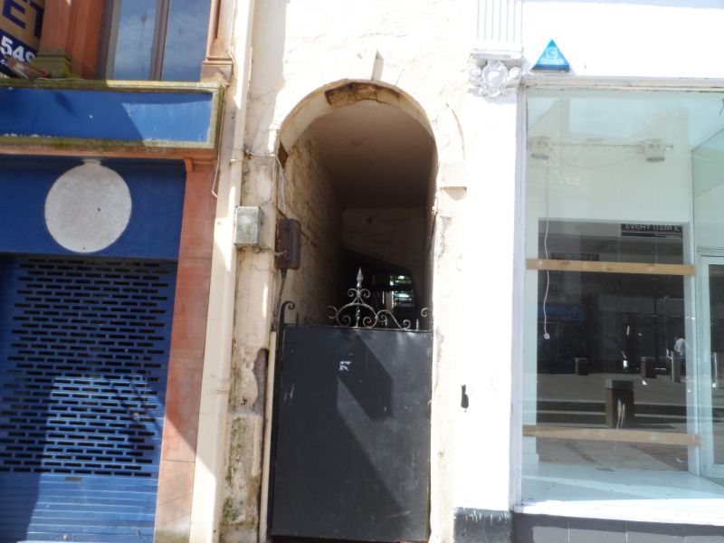
Early 19th century. 3 storeys, 3 bays, with shop at ground
with late 19th century flanking pilasters supporting fascia;
iron-gated round-arched pend to left. Painted coursed rubble
and ashlar margins. Originally single windows throughout,
inner 1st floor window now a bipartite; plate glass sashes
throughout; eaves/lintel band; cornice; end stacks; slate
roof.
External links are from the relevant listing authority and, where applicable, Wikidata. Wikidata IDs may be related buildings as well as this specific building. If you want to add or update a link, you will need to do so by editing the Wikidata entry.


Other nearby listed buildings
