Approximate Location Map
Large Map »
Latitude: 55.0676 / 55°4'3"N
Longitude: -3.6151 / 3°36'54"W
OS Eastings: 296957
OS Northings: 575988
OS Grid: NX969759
Mapcode National: GBR 396V.46
Mapcode Global: WH5WJ.FWRG
Plus Code: 9C7R399M+3X
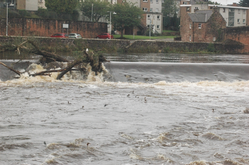
Entry Name: Weir, River Nith, Dumfries
Listing Name: Whitesands Caul
Listing Date: 21 August 1987
Category: B
Source: Historic Scotland
Source ID: 362980
Historic Scotland Designation Reference: LB26353
Building Class: Cultural
Also known as: The Caul
ID on this website: 200362980
Location: Dumfries
County: Dumfries and Galloway
Town: Dumfries
Electoral Ward: North West Dumfries
Traditional County: Dumfriesshire
Tagged with: Weir
Matthew Frew, contractor. Built circa 1705. Caul (Weir),
obliquely crossing River Nith near Devorgilla's bridge; opening
to mill lade on W bank, fish gullet near each bank with (later)
ponds below larger E gullet. All built of large squared
rubble blocks.
A group with Devorgilla Bridge. Unusually large and early weir;
built in conjunction with (rebuilt) Town Mill; includes fish
ladders.
External links are from the relevant listing authority and, where applicable, Wikidata. Wikidata IDs may be related buildings as well as this specific building. If you want to add or update a link, you will need to do so by editing the Wikidata entry.


Other nearby listed buildings
