Approximate Location Map
Large Map »
Latitude: 55.0682 / 55°4'5"N
Longitude: -3.6162 / 3°36'58"W
OS Eastings: 296890
OS Northings: 576053
OS Grid: NX968760
Mapcode National: GBR 395T.XZ
Mapcode Global: WH5WJ.FW70
Plus Code: 9C7R399M+7G
Entry Name: Old Bridge, Dumfries
Listing Name: Whitesands, Devorgilla Bridge
Listing Date: 11 July 1961
Category: A
Source: Historic Scotland
Source ID: 362981
Historic Scotland Designation Reference: LB26354
Building Class: Cultural
Also known as: Devorgilla Bridge
Devorguilla's Bridge
ID on this website: 200362981
Location: Dumfries
County: Dumfries and Galloway
Town: Dumfries
Electoral Ward: Nith
Traditional County: Dumfriesshire
Tagged with: Bridge Road bridge
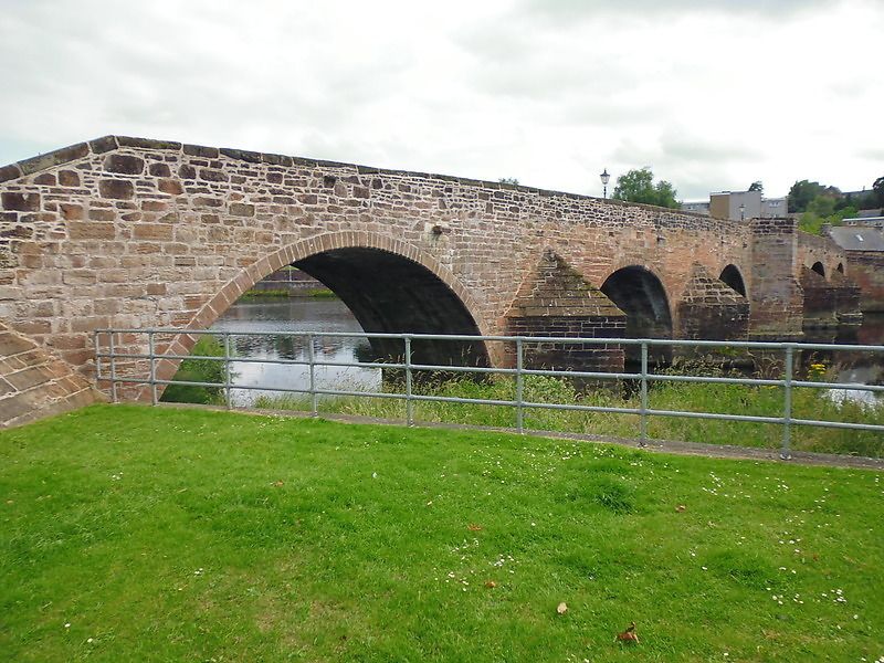
Building began circa 1431, but much rebuilt and altered. Bridge comprising 6 - originally 9 - arches over River Nith. 1619
flood demolished 5 arches, these rebuilt (doubtless on 15th
century piers or footings) 1620-21. Frequently repaired, eg
Gilbert Smith, 1725; parapets rebuilt. 3 eastmost arches
demolished in first half of 19th century as part of Whitesands
land reclamation scheme. Built of coursed red sandstone,
arches with ashlar voussoirs with chamfered edges and unribbed
soffits, pointed cutwaters splayed inwards below level of
arch crowns, central cutwaters carried upwards as pedestrian
refuges and mark site of former "port" (toll-gate), demolished
1769 to lessen weight on pier (there had previously been
2 ports). Eastmost half of bridge is fairly regular on plan
with parapets set at lower level (eastmost arch is slightly
wider, steps at truncated E end; westmost half of bridge is
irregular on plan), suggesting earlier building date,
particularly at pointed westmost arch; abutments and parapets
splayed towards N, perhaps to allow for possible defence.
Scheduled Monument. Replaces earlier (?timber) bridge, usually attributed to Devorgilla Baliol, foundress of Sweetheart
Abbey in late 13th century. Diary of Wm Grierson (copy in
Ewart library) notes (p. 147) on 27th Oct 1794 "This day the
Arch of the old bridge was taken down to open the road to
the New Bridge,..."; but some early 19th century illustrations
show 9 arches, and Gough in 1806 counted 9 arches (Edgar,
p. 158n). Dickie agrees that one arch was removed 1794,
adding that the last arch was removed in 1825. Before the
New (Buccleuch St) bridge was built, Alexander Stevens
produced in 1791 a design for widening this bridge (see
Edgar, p. 158n, quoting TCM). Pemberton, in his Journal,
1723, remarks on this "....fair stone bridge of 13 large
arches, the finest I saw in Britain next to London and
Rochester...."; MacDowall, however, shows (Guide to Dumfries)
1885, 3rd ed, pp. 66-8) that so far back as 1681 there were
still only 9 arches. Excavations by James Barbour failed to
find evidence of a 10th arch.
External links are from the relevant listing authority and, where applicable, Wikidata. Wikidata IDs may be related buildings as well as this specific building. If you want to add or update a link, you will need to do so by editing the Wikidata entry.


Other nearby listed buildings
