Approximate Location Map
Large Map »
Latitude: 56.189 / 56°11'20"N
Longitude: -3.9631 / 3°57'47"W
OS Eastings: 278266
OS Northings: 701328
OS Grid: NN782013
Mapcode National: GBR 1B.G3LZ
Mapcode Global: WH4NT.3P2T
Plus Code: 9C8R52QP+HQ
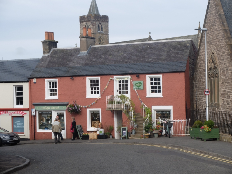
Entry Name: 91-95 High Street, Dunblane
Listing Name: 91-95 (Odd Nos) High Street
Listing Date: 28 October 1971
Category: B
Source: Historic Scotland
Source ID: 363011
Historic Scotland Designation Reference: LB26388
Building Class: Cultural
ID on this website: 200363011
Location: Dunblane
County: Stirling
Town: Dunblane
Electoral Ward: Dunblane and Bridge of Allan
Traditional County: Perthshire
Tagged with: Cottage
Late 18th century. 2-storey and basement; 4-bay; semi-detached tenement with shop at ground floor. Ground and 1st floor entrances vertically aligned; curved forestair to 1st floor entrance. Harled with painted stone dressings. Architraved openings with chamfered reveals to principal (SE) elevation (apart from to later shop front).
SE (PRINCIPAL) ELEVATION: entrance (2-leaf boarded timber door) to right of centre. Curved forestair (with later 20th century railings) to entrance above; replacement part-glazed door. Windows to flanking bays at ground and 1st floor; that to right of ground floor enlarged. Inserted shop front (probably later 19th century) to outer left bay: large window with adjoining entrance to right surmounted by corniced fascia board. Wrought-iron bracket (for suspending sign) of Art Nouveau design in bay to left of centre at 1st floor. Basement visible externally only to outer right.
12-pane timber sash and case windows to 1st floor of principal (SE) elevation; single-pane replacement windows at ground. Grey slate roof. Harled coped gablehead stack to SW; harled coped ridge stack; round cans.
INTERIOR: not seen 2001.
A distinctive late 18th century tenement block retaining a rare example of a curved forestair. A building appears to be shown in this location on a map of 1817 (McKerracher) and is identifiable on the 1st Edition OS Map. This (upper section) of the high street appears to have developed in importance during the later 19th century (probably when the ground floor shop front was inserted).
External links are from the relevant listing authority and, where applicable, Wikidata. Wikidata IDs may be related buildings as well as this specific building. If you want to add or update a link, you will need to do so by editing the Wikidata entry.


Other nearby listed buildings
