Approximate Location Map
Large Map »
Latitude: 55.9533 / 55°57'11"N
Longitude: -3.1096 / 3°6'34"W
OS Eastings: 330812
OS Northings: 673919
OS Grid: NT308739
Mapcode National: GBR 2C.XWY9
Mapcode Global: WH6SN.6MHH
Plus Code: 9C7RXV3R+85
Entry Name: 34, 36 Marlborough Street, Edinburgh
Listing Name: 34 and 36 Marlborough Street
Listing Date: 14 December 1970
Category: B
Source: Historic Scotland
Source ID: 364507
Historic Scotland Designation Reference: LB27364
Building Class: Cultural
ID on this website: 200364507
Location: Edinburgh
County: Edinburgh
Town: Edinburgh
Electoral Ward: Portobello/Craigmillar
Traditional County: Midlothian
Tagged with: House
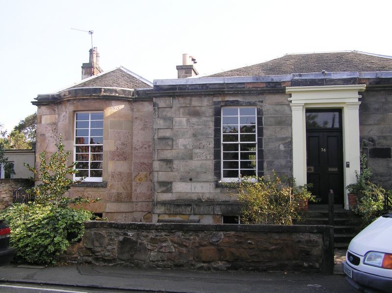
Earlier 19th century with later alterations and additions (now subdivided into two houses). Single storey, with basement, 3-bay classical house with pavilions flanking. Finely droved, polished ashlar dressings; ashlar pavilions, rendered and lined; rubble with droved ashlar dressings to side elevations; harled rear elevation. Broad band course dividing basement from ground, cornice and blocking course; slightly raised quoins to main house.
NW (PRINCIPAL) ELEVATION: 5 steps to pilastered doorpiece with tablet above entablature with deep-set panelled door to centre, plate glass fanlight above. Windows at ground and basement of flanking bays (now blinded at No 34). Pavilions with full-height bowed windows, windows at ground and half-basement.
NE AND SW (SIDE) ELEVATIONS: 2 blinded windows; small window in between.
SE (REAR) ELEVATION: small single storey extension at bay to centre (property of No 36); windows to flanking bays. Pavilions with gable end and windows at ground.
16-lying-pane timber sash and case windows; plate glass
windows to rear. Grey slate piended roof to main house; piended grey slate roof with gable ends to pavilions (with ridge over bowed window to No 34; curved to No 36). Wallhead stacks (rendered to No 34; rubble and rendered to No 36) to side elevations of pavilions.
INTERIORS: not seen, 1994.
BOUNDARY WALL: partly rubble with coping; partly rendered with coping.
The house is not shown upon Wood's map, 1824, although BUILDINGS OF SCOTLAND notes that it was built in 1816 for the City Chamberlain, Thomas Henderson. The house was called Wellington Lodge. (It is shown under this name on the 1st edition OS map, 1854.) Baird mentions the house and its ownership under Mr Henderson, yet his description as standing "in extensive orchard grounds at the top of Wellington Street facing the main road" (P 321), does not correspond to the site of this building.
External links are from the relevant listing authority and, where applicable, Wikidata. Wikidata IDs may be related buildings as well as this specific building. If you want to add or update a link, you will need to do so by editing the Wikidata entry.


Other nearby listed buildings
