Approximate Location Map
Large Map »
Latitude: 55.9219 / 55°55'18"N
Longitude: -3.3803 / 3°22'49"W
OS Eastings: 313837
OS Northings: 670726
OS Grid: NT138707
Mapcode National: GBR 21.ZVZJ
Mapcode Global: WH6SQ.1FL2
Plus Code: 9C7RWJC9+PV
Entry Name: 62, 64 Main Street, Ratho
Listing Name: Ratho Village, 62-64 (Even Nos), Main Street
Listing Date: 22 January 1971
Category: B
Source: Historic Scotland
Source ID: 365111
Historic Scotland Designation Reference: LB27781
Building Class: Cultural
ID on this website: 200365111
Location: Edinburgh
County: Edinburgh
Town: Edinburgh
Electoral Ward: Pentland Hills
Traditional County: Midlothian
Tagged with: Architectural structure
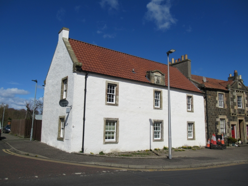
Late 18th century. 2 storey; 3-bay; rectangular-plan house. Rendered with sandstone dressings.
S (STREET) ELEVATION: windows regularly disposed; 3 at ground; 3 (slightly narrower) at 1st floor. Evidence of blocked opening between bays to right (originally main front, now rear). Shaped pediment above eaves at centre; droved sandstone; armorial panel within with bolection moulding at centre.
W ELEVATION: gable end; window at ground and 1st floor to right. Scrolled skewputts.
N (REAR) ELEVATION: reconstructed. 5-bay main block grouped 2:3 at ground and 1st floor. Entrance wing projecting at outer left.
12-pane sash and case windows. Red pantiled roof with semi-circular ridge tiles. Ashlar coping to skews; scrolled skewputts on W gable. Broad coped end stack to E; narrow coped gablehead stack to W.
Formerly listed as 68-70 Main Street (Masonic Lodge). Early 20th century photographs show substantial alterations. Originally the main frontage was to the street; 6-bay at ground floor consisting of centre main door with window and door to left and window, door, window to right. The W gable was blank in the 1900s photograph. The building was derelict at time of first listing and was subsequently repaired.
External links are from the relevant listing authority and, where applicable, Wikidata. Wikidata IDs may be related buildings as well as this specific building. If you want to add or update a link, you will need to do so by editing the Wikidata entry.


Other nearby listed buildings
