Approximate Location Map
Large Map »
Latitude: 55.9515 / 55°57'5"N
Longitude: -3.1132 / 3°6'47"W
OS Eastings: 330585
OS Northings: 673724
OS Grid: NT305737
Mapcode National: GBR 2C.Y2JQ
Mapcode Global: WH6SN.4NTV
Plus Code: 9C7RXV2P+JP
Entry Name: 15-17 Windsor Place, Portobello, Edinburgh
Listing Name: 13, 15 and 17 Windsor Place
Listing Date: 14 December 1970
Category: B
Source: Historic Scotland
Source ID: 365144
Historic Scotland Designation Reference: LB27811
Building Class: Cultural
ID on this website: 200365144
Location: Edinburgh
County: Edinburgh
Town: Edinburgh
Electoral Ward: Portobello/Craigmillar
Traditional County: Midlothian
Tagged with: Architectural structure
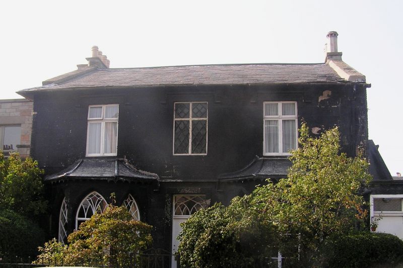
Early 19th century, with later alterations and additions. 2-storey, 3-bay Tudor-Gothick house, now subdivided by floor. Finely droved ashlar, vermiculated dressings, possibly all tar covered; rubble S elevation, squared render to N elevation. Base course, strip quoins.
E (PRINCIPAL) ELEVATION: symmetrical; deep-set flush panelled Edinburgh door to centre; rectangular fanlight above with ornamental tracery, vermiculated doorpiece with moulded square hoodmould; blinded window with leaded lights at 1st floor above. Single storey canted windows to flanking bays, windows at 1st floor above with moulded square hoodmoulds. Later brick with render staircase extension to right, giving access to 1st floor.
W (REAR) ELEVATION: not seen; T-shaped extension from bay to centre.
Pointed-arch windows to ground floor; timber lattice windows to either side of canted windows; 10-lying pane timber casement windows to centre, ornamental tracery to upper sections with some stained glass incorporated; modern timber mullioned windows to 1st floor with pivoted upper section. Purple slate roof; valanced canted windows; rendered and coped stacks.
INTERIORS: not seen, 1994.
BOUNDARY WALLS: rendered with coping.
Named Fairfield Cottage (now adopted by No 9) on Sutter's map. Formerly with building adjoining to S, seen on Wood's and Sutter's maps, and which was demolished in 1967.
External links are from the relevant listing authority and, where applicable, Wikidata. Wikidata IDs may be related buildings as well as this specific building. If you want to add or update a link, you will need to do so by editing the Wikidata entry.


Other nearby listed buildings
