Approximate Location Map
Large Map »
Latitude: 55.9537 / 55°57'13"N
Longitude: -3.1872 / 3°11'13"W
OS Eastings: 325965
OS Northings: 674041
OS Grid: NT259740
Mapcode National: GBR 8PF.W8
Mapcode Global: WH6SM.0MK6
Plus Code: 9C7RXR37+F4
Entry Name: Regent Bridge, Edinburgh
Listing Name: Regent Bridge Carrying Waterloo Place over Calton Road Including Railings
Listing Date: 19 April 1966
Category: A
Source: Historic Scotland
Source ID: 365316
Historic Scotland Designation Reference: LB27945
Building Class: Cultural
Also known as: Edinburgh, Regent Bridge
ID on this website: 200365316
Location: Edinburgh
County: Edinburgh
Town: Edinburgh
Electoral Ward: City Centre
Traditional County: Midlothian
Tagged with: Arch bridge
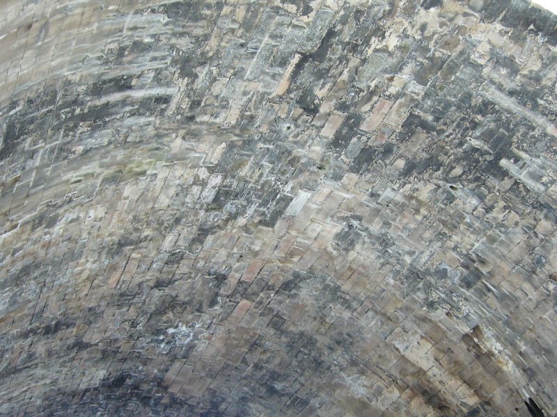
Archibald Elliot, with Robert Stevenson, 1815-19. Single semicircular-span bridge over Calton Road surmounted by classical screens on either side of Waterloo Place. Droved ashlar with polished voussoirs and polished ashlar to screens. Impost course; archivolt; band course; crowning cornice.
Pair of screens to Waterloo Place with base course, entablature and blocking course. Central semicircular arch with console keystone and archivolt, framed by engaged Corinthian columns; flanking to right and left, lower Ionic colonnade; flanked at outer right and left by advanced section of wall with central blind niche, recessed panel above.
RAILINGS: spear-head finialled cast iron railings set on ashlar copes, running full length of Waterloo Place elevations.
A Group with Nos 6-20 Waterloo Place, Nos 1-29 Waterloo Place. Waverleygate, Register House and Balmoral Hotel.
The Regent Bridge is of great significance, both as an outstanding feat of civil engineering and as an important architectural element of the Waterloo Place scheme. The bridge, 50 feet high, was the first to span the deep ravine known as Low Calton, enabling the construction of a new access road from Princes Street to the east. The scheme as a whole forms the critical element of the vista up Princes Street towards Calton Hill and the east and creates an impressive entry to Princes Street from the east. The 'triumphal arch' form of the screens is significant as they commemorate the Battle of Waterloo. Their Ionic colonnades also link stylistically to the classical facades of Waterloo Place. Regent Bridge is a major example of the Greek Revival work of Archibald Elliot, one of Edinburgh's leading architects in the early 19th century. On the screen to the North of Waterloo Place is an inscribed panel which reads, 'COMMMENCED IN THE EVER MEMORABLE YEAR 1815. SIR JOHN MAJORIBANKS OF LEES, BARONET, M.P., LORD PROVOST OF THE CITY. ARCHIBALD ELLIOT, ARCHITECT'. Above, is 'THE REGENTS BRIDGE'
The screen to the South of Waterloo Place is inscribed with 'OPENED AUGUST 18TH 1819 FOR THE ENTRY OF HIS ROYAL HIGHNESS PRINCE LEOPOLD OF SAXE COBURG'.
A plan to form an access to Calton Hill from the east end of Princes Street had been suggested as early as 1790. However, at the time it was thought to be impractical due to the difficulties of gaining permission to disturb the Calton Burying Ground and the expense involved in acquiring and demolishing the properties which stood on the new route. By 1813, two major new developments made the new route a viable necessity. Firstly, in 1811-12, plans had begun to be formed for the construction of the New Town to the east, the centre piece of which was to be a development on the east side of Calton Hill. Secondly, in 1814, an Act was passed which designated the south slopes of Calton Hill as the location of the new national gaol. Access to Calton Hill at this time was circuitous and difficult.
The Acts of 1813 and 1814 appointed commissioners to oversee the construction of the new bridge and road over the Low Calton ravine and instructed the acquisition of the necessary properties and the intersection of the Calton Burying Ground. In January 1815 Robert Stevenson was appointed as engineer for the scheme. By December 1815, Archibald Elliot's designs for the buildings and bridge had been chosen over those of Gillespie Graham and Crichton, and Elliot was appointed as architect for the scheme. Stevenson himself had submitted a report which stressed the desirability of retaining the spectacular views of the city and beyond which would be gained from the bridge. Elliot's final design accorded in part with Stevenson's views; the views to the north and south were retained through the use of an open colonnade above the bridge's principal span. The contract for the bridge was signed in the summer of 1816, and construction duly commenced. It was officially opened during the visit of Prince Leopold of Saxe Coburg in 1819.
References from previous list description: M S Irvine, Historical Notes - The Calton or Caldtoun of Edinburgh, 1631-1887 (Cowan Bequest, Edinburgh Room, Edinburgh Central Library). The Book of the Old Edinburgh Club 1933 pp134-5. I. Nimmo Edinburgh The New Town (1991) pp 63-64.
List description revised as part of Edinburgh Holyrood Ward resurvey 2007-08.
External links are from the relevant listing authority and, where applicable, Wikidata. Wikidata IDs may be related buildings as well as this specific building. If you want to add or update a link, you will need to do so by editing the Wikidata entry.


Other nearby listed buildings
