Approximate Location Map
Large Map »
Latitude: 55.9491 / 55°56'56"N
Longitude: -3.1962 / 3°11'46"W
OS Eastings: 325395
OS Northings: 673541
OS Grid: NT253735
Mapcode National: GBR 8NG.2X
Mapcode Global: WH6SL.WQ5Q
Plus Code: 9C7RWRX3+JG
Entry Name: Reservoir, 555 Castlehill, Edinburgh
Listing Name: 555 Castlehill, Former Reservoir, with Retaining Wall, Steps, Railings and Balustrade to N and Drinking Fountain on W Wall
Listing Date: 13 August 1987
Category: B
Source: Historic Scotland
Source ID: 365334
Historic Scotland Designation Reference: LB27962
Building Class: Cultural
ID on this website: 200365334
Location: Edinburgh
County: Edinburgh
Town: Edinburgh
Electoral Ward: City Centre
Traditional County: Midlothian
Tagged with: Architectural structure Monument
Rendel and Beardmore, 1849-50. Single storey and basement rectangular-plan former reservoir, 9 bays to Castlehill, 7 to Ramsay Lane; 3-stage Italianate tower with balustraded parapet at centre of N (Ramsay Garden) elevation. Lightly stugged ashlar with polished dressings. Channelled basement to N and E. Swept corniced and blocking course. Long and short quoins to corner blocks and tower. Windows in tabbed surrounds.
S (CASTLEHILL) ELEVATION: slightly advanced bay to left with 2-leaf timber door in pedimented moulded surround.
E (RAMSAY LANE) ELEVATION: modern vehicular entrance to right.
N (RAMSAY GARDEN) ELEVATION: 3-stage tower to centre: string courses between stages; long and short quoins; round-arched windows to 3rd stage.
INTERIOR: lit by rectangular glazed cupola. Timber beams and trusses of roof supported by cast-iron columns.
RETAINING WALL, BALUSTRADE, STEPS AND RAILINGS: curved ashlar-coped sandstone retaining wall with ashlar steps, decorative wrought-iron railings and balustrade with terracotta balusters (see Notes).
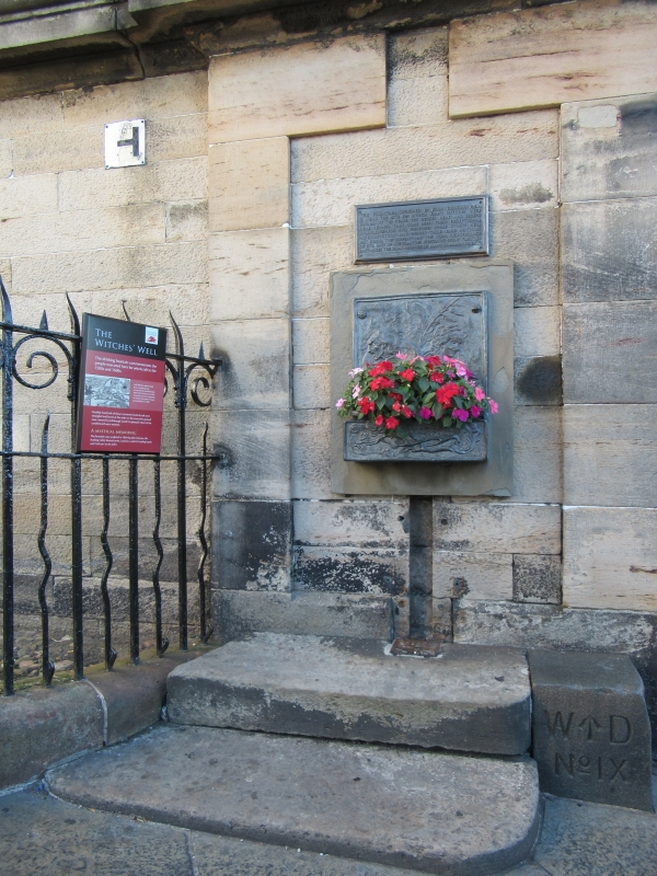
DRINKING FOUNTAIN: bronze relief and plaque to outer right of W wall.
Built on the site of a smaller reservoir, of circa 1755, itself built on the site of an earlier chapel (shown on Gordon of Rothiemay's plan of 1647). Part of Edinburgh's early and extensive water supply, an Act concerning which was passed in 1621. The 1st main was brought from Comiston Springs by Peter Brauss, engineer, in 1681. Property disputes delayed switch-on until 1720, when water was piped to several cisterns designed by Sir William Bruce. In the 1820's Edinburgh Joint Stock Water Company began to pipe water direct to houses. According to Grant, 2 million gallons of water could be distributed form the reservoir at the rate of 5,000 gallons per minute. The deep basement area of the former reservoir is now used as shop/exhibition area. Alterations including the wrought-iron railings and balustrade appear to have been made to the retaining wall to N at the time of the building of Ramsay Garden (1892-3) probably by Sydney Mitchell. Drinking fountain on the W wall of the building is near the site where condemned witches were burned. Bronze relief by John Duncan shows evil head facing to left, serene to right, with foxgloves and entwined serpent.
External links are from the relevant listing authority and, where applicable, Wikidata. Wikidata IDs may be related buildings as well as this specific building. If you want to add or update a link, you will need to do so by editing the Wikidata entry.


Other nearby listed buildings
