Approximate Location Map
Large Map »
Latitude: 55.9146 / 55°54'52"N
Longitude: -3.1774 / 3°10'38"W
OS Eastings: 326504
OS Northings: 669680
OS Grid: NT265696
Mapcode National: GBR 8RW.W8
Mapcode Global: WH6ST.5L6N
Plus Code: 9C7RWR7F+R2
Entry Name: Liberton Tower, Liberton Drive, Edinburgh
Listing Name: Liberton Drive, Liberton Tower
Listing Date: 14 July 1966
Category: A
Source: Historic Scotland
Source ID: 365439
Historic Scotland Designation Reference: LB28021
Building Class: Cultural
ID on this website: 200365439
Location: Edinburgh
County: Edinburgh
Town: Edinburgh
Electoral Ward: Liberton/Gilmerton
Traditional County: Midlothian
Tagged with: Tower house
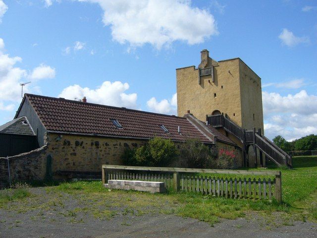
Circa 1500. Late-medieval tower house. Rectangular plan, 4-storey, coursed rubble with dressed quoins and openings, arrow slits and gun-loops. Barrel- vaulted basement, upper storey pointed tunnel vault, original access by round-arched door to 1st floor to E. Timber floors which formed 2 storeys between vaults now missing. Low parapet, rubble gablehead stacks to E and W, parapet walk with drainage channels and stone flagged roof.
BASEMENT: door to S, enlarged as interrupts corbels for joists. Arrow slit openings to N, S and E. No access to upper floors.
ENTRESOL: probably used as store. Accessible from 1st floor via narrow mural stair in NW angle. Hatch in vault probably later. Slit openings to each elevation.
FIRST FLOOR: principal floor with round-arched doorway to E, windows to N and S. Plain fireplace in S wall, staircases in NW (down) and SW (up) angles, garderobe on NE angle with soil flue, lamp recess and 2 small windows. Aumbry with depressed ogee head in NE (damaged by later door). Spyhole to straight stair in E wall rising to 2nd floor.
SECOND FLOOR (ENTRESOL): originally divided into 2 chambers with timber partition N-S. Fireplace in W and E wall. Opening to E gable, garderobe in NE angle. Parapet walk accessed by ladder.
Now in residential use. Descheduled (2008). Tower and interior are well illustrated in MacGibbon and Ross. The Inventory refers to a charter which granted the lands of Upper or Over Liberton to Alexander de Dalmahoy in 1475-6. The tower, sited on ridge to S of city, is remarkably complete; Gifford, McWilliam & Walker date the building c.1500 by the aumbry with depressed ogee head. Masonry and parapet walk resemble Craigmillar Castle (to NE). The Inventory suggests that the very low parapet may have been raised with timber merlons.
Illustration in MacGibbon & Ross shows joists of entresol floors in place. The two neighbouring former farmhouses are listed separately. An early cross shaft, found built into a wall adjoining the tower, with interlace and key pattern ornament was removed and presented to the National Museum of Antiquities in 1863 (See Inventory Item No: 168).
External links are from the relevant listing authority and, where applicable, Wikidata. Wikidata IDs may be related buildings as well as this specific building. If you want to add or update a link, you will need to do so by editing the Wikidata entry.


Other nearby listed buildings
