Approximate Location Map
Large Map »
Latitude: 55.9069 / 55°54'24"N
Longitude: -3.2603 / 3°15'37"W
OS Eastings: 321305
OS Northings: 668915
OS Grid: NT213689
Mapcode National: GBR 87Z.21
Mapcode Global: WH6SR.WSNL
Plus Code: 9C7RWP4Q+QV
Entry Name: Spylaw House, 25 Spylaw Street, Colinton, Edinburgh
Listing Name: 25 Spylaw Street, Spylaw House
Listing Date: 14 July 1966
Category: B
Source: Historic Scotland
Source ID: 365567
Historic Scotland Designation Reference: LB28124
Building Class: Cultural
ID on this website: 200365567
Location: Edinburgh
County: Edinburgh
Town: Edinburgh
Electoral Ward: Colinton/Fairmilehead
Traditional County: Midlothian
Tagged with: House Architectural structure
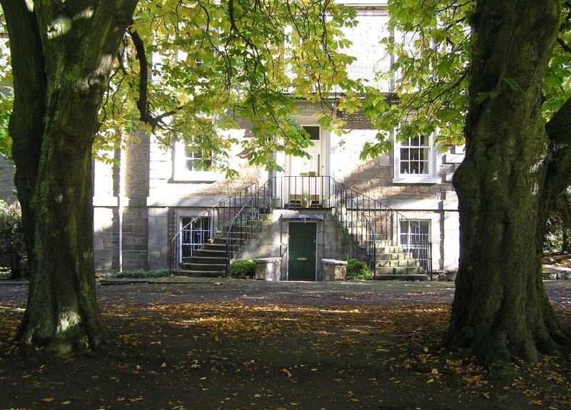
1773 house with circa 1650 former mill to E. 2-storey, basement and attic, approximately L-plan piend-roofed house with former snuff mill to rear. Slightly advanced 3-bay pedimented centrepiece with horse-shoe perron to W; recessed bay to outer left. 17th century former mill advanced from left side of E elevation. Coursed sandstone rubble to 1773 house; random rubble to 1650 wing; droved and polished ashlar dressings. Bandcourse above basement and eaves course to 1773 house; long and short quoins, raised quoins to centrepiece; raised window margins.
W (PRINCIPAL) ELEVATION: 3-bay advanced centrepiece, regularly fenestrated; central timber panelled front door with fanlight in corniced, consoled architrave with central Adam-style festoon and rosette panel to freize; horse shoe perron to door with alternating plain and barley-twist railings; timber panelled door beneath steps with splayed side walls. Small arched window to pediment with hoodmould and blind panel below. Painted, corniced architraves to windows flanking door. Decorative wrought-iron balcony to first floor at central and right windows. Recessed windowless bays flanking centrepiece; windows to left return, window at ground with keyblocked relieving arch. Possibly later recessed bay to outer left; windows at all floors.
N (SIDE) ELEVATION: stepped composition. Single bay to centre, with non-traditional door in key-blocked arch at ground; windows to left return. Advanced bay (possibly later ? see above) to outer right with single window at ground to centre; irregular fenestration to left return. 2-bay 1650 wing recessed to outer left; regularly fenestrated with non-traditional glazed door with sidelight at ground to centre.
E (WATER OF LEITH) ELEVATION: of 1650 wing. Gable with gable-head stack; regularly fenestrated at top 2 floors; single window, off-centre at ground.
S (SIDE) ELEVATION: Stepped composition. 1773 house advanced to left; regular fenestration in 3 bays; blind windows to right return. Recessed single bay at oblique angle to centre; modern 2-leaf glazed door approached by flight of steps at ground; tall staircase window above. 1650 wing 2 bays to left with regular fenestration at top 2 floors and single, later, slate-hung dormer to outer right.
12-pane glazing in timber sash and case windows. Irregularly placed corniced and coped stacks with yellow clay cans. Graded grey slates.
INTERIOR: converted into 8 flats with very few original interior features remaining.
This was the house of James Gillespie, who made a fortune from snuff milling and was the founder of Gillespie's Hospital. The older part of this building is believed to date from about 1650, and was built as a mill (this is apparent from its proximity to the Water of Leith). Although some mills are known to have existed in this area in the late 16th century (permission was granted for a paper mill to be built at the site of Upper Spylaw Mill in 1590), industrialisation was very slow, and still in its infancy in the mid 17th century. Therefore, this mill is not only one of the oldest mill buildings to survive, but probably one of the earliest to have been built. Industrialisation was more rapid from the mid 18th century onwards, and reached a peak in the nineteenth century. The New Statistical Account (1834) states that there were 16 mills in Colinton Parish (which included Juniper Green and Slateford), with another being built. Of these, 10 produced flour, meal or barley, 4 were paper mills and 3 were snuff mills. 3 of these mills also had sidelines in grinding minerals, sawing wood and beating hemp; it was not uncommon for the mills to change their produce according to demand. Gillespie bought the mill in 1773, and added a house to the front of it for himself (possible replacing an earlier house). The architect of the house is unknown. The snuff which he produced was sold by his brother from a shop in the High Street, near to the City Chambers (the shop is marked with a plaque). Gillespie died in 1797 and is buried at St Cuthbert's in Dell Road, where he has a handsome tomb. He left most of his property, including the house, but not the mill, to support the foundation of Gillespie's Hospital. The mill building was acquired by the govenors of the Trust in 1846.
External links are from the relevant listing authority and, where applicable, Wikidata. Wikidata IDs may be related buildings as well as this specific building. If you want to add or update a link, you will need to do so by editing the Wikidata entry.


Other nearby listed buildings
