Approximate Location Map
Large Map »
Latitude: 55.9622 / 55°57'43"N
Longitude: -3.1608 / 3°9'38"W
OS Eastings: 327633
OS Northings: 674963
OS Grid: NT276749
Mapcode National: GBR 8WB.86
Mapcode Global: WH6SM.FD3N
Plus Code: 9C7RXR6Q+VM
Entry Name: Lochend Park, Edinburgh
Listing Name: Lochend Road South, Lochend Park, Lochend Castle Dovecot
Listing Date: 14 December 1970
Category: B
Source: Historic Scotland
Source ID: 365592
Historic Scotland Designation Reference: LB28142
Building Class: Cultural
ID on this website: 200365592
Location: Edinburgh
County: Edinburgh
Town: Edinburgh
Electoral Ward: Craigentinny/Duddingston
Traditional County: Midlothian
Tagged with: Dovecote
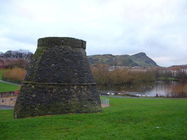
16th century. Beehive type dovecot, rubble stone, rat-course alighting ledge at mid point, circular opening in roof, large entrance to E, remnants of stone pigeon hole ledges within. Altered; top heightened with collar of masonry, window blocked above rat-course.
Said to have been used as a kiln during the plague of 1645. Used as a boat house by the Humane Society circa 1860.
External links are from the relevant listing authority and, where applicable, Wikidata. Wikidata IDs may be related buildings as well as this specific building. If you want to add or update a link, you will need to do so by editing the Wikidata entry.


Other nearby listed buildings
