Approximate Location Map
Large Map »
Latitude: 55.9361 / 55°56'10"N
Longitude: -3.174 / 3°10'26"W
OS Eastings: 326759
OS Northings: 672075
OS Grid: NT267720
Mapcode National: GBR 8SM.LK
Mapcode Global: WH6ST.62V3
Plus Code: 9C7RWRPG+FC
Entry Name: 15 Blacket Place, Edinburgh
Listing Name: 15 Blacket Place, Including Boundary Walls
Listing Date: 14 December 1970
Category: B
Source: Historic Scotland
Source ID: 366051
Historic Scotland Designation Reference: LB28302
Building Class: Cultural
ID on this website: 200366051
Location: Edinburgh
County: Edinburgh
Town: Edinburgh
Electoral Ward: Southside/Newington
Traditional County: Midlothian
Tagged with: House
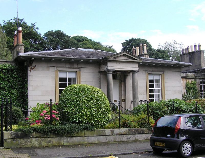
Earlier 19th century, before 1833. Single storey symmetrical rectangular-plan classical villa with basement and recessed single bay wings. Polished sandstone ashlar; rubble to wings, sides and rear. Base course; eaves course; deeply overhanging eaves; architraved windows.
W (ENTRANCE) ELEVATION: steps up to pedimented doorcase supported by Doric columns with single pilasters behind; 4-panelled timber door with 3-pane fanlight; single aproned windows to flanking bays. Corniced wing to left, extends to rear; advanced window bay; steps down to iron gate with door behind to basement. Advanced window bay to corniced wing to right, continuous with wing of No 17. 2 windows to left of basement, 3 to right.
12-pane lying-pane sash and case windows to ground. Basement windows: 2-pane sash and case (left); 2 8-pane sash and case to either side of 16-pane sash and case (right). Grey slate piended roof with deep eaves. Coped wallhead stacks; tall octagonal cans.
INTERIOR: not seen 1996.
BOUNDARY WALLS: low coped boundary wall to street with pineapple finials to iron posts supporting 2 swagged iron chains; lattice ironwork gatepiers to pedestrian entrance; corniced piers flank coped and coursed rubble boundary walls to street.
One of the earliest buildings in Blacket Place, thought to be by Thomas Hamilton. Dr Benjamin Bell of Hunthill, an eminent Edinburgh surgeon and farmer, speculated on the potential for development in the lands of Newington. In 1806, aware of the demand for countrified dwellings near the city, he advertised his intention to sell 58 plots of land within his 8.5 acres. On his death in the same year his son George Bell, also a surgeon, inherited the land and, in 1825, commissioned James Gillespie Graham to design a plan for new streets within the grounds of Newington House, bounded by the back garden walls of Minto Street, Salisbury Road, East Mayfield and Dalkeith Road. Feus were offered for sale and Blacket Place began to take shape. Security was an important feature of the development, with Gothic gates, the octagonal piers of which survive, locked at night and single storey lodges at the entrances from Minto Street and Dalkeith Road.
External links are from the relevant listing authority and, where applicable, Wikidata. Wikidata IDs may be related buildings as well as this specific building. If you want to add or update a link, you will need to do so by editing the Wikidata entry.


Other nearby listed buildings
