Approximate Location Map
Large Map »
Latitude: 55.9584 / 55°57'30"N
Longitude: -3.2003 / 3°12'1"W
OS Eastings: 325157
OS Northings: 674586
OS Grid: NT251745
Mapcode National: GBR 8MC.7K
Mapcode Global: WH6SL.TH7J
Plus Code: 9C7RXQ5X+9V
Entry Name: 39, 41 Cumberland Street, Edinburgh
Listing Name: 68-76 (Even Nos) Dundas Street and 39-41 (Odd Nos) Cumberland Street, Including Railings
Listing Date: 10 November 1966
Category: A
Source: Historic Scotland
Source ID: 367180
Historic Scotland Designation Reference: LB28720
Building Class: Cultural
ID on this website: 200367180
Location: Edinburgh
County: Edinburgh
Town: Edinburgh
Electoral Ward: City Centre
Traditional County: Midlothian
Tagged with: Architectural structure
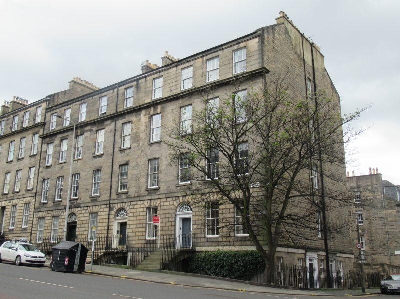
Probably Thomas Bonnar, early 19th century. 4-storey and basement, 9-bay terraced tenement. Broached ashlar sandstone; V-jointed rustication at principal floor. Band course between basement and principal floor, principal floor and 1st floor; projecting cills to windows at 1st and 2nd floors; continuous cornice at 2nd floor; cornice and blocking course at 3rd floor. Ashlar steps and entrance platts oversailing basement.
E (PRINCIPAL) ELEVATION: 6-panel timber common stair door in round-arched doorpiece centred at principal floor; 6-panel timber doors in bays 3rd form left and right; with radial semicircular fanlights. Windows in remaining bays at principal floor; regular fenestration to floors above.
N (CUMBERLAND STREET) ELEVATION: coursed rubble gable, comprising 6-bay basement, with pilastered and corniced doorpieces, panelled timber doors and multi-pane rectangular fanlights, in bays 3rd and 5th from left, windows in remaining bays; windows centred to floors above.
S ELEVATION: adjoining terrace, see separate listing (56-66A Dundas Street).
12-pane timber sash and case windows. Grey slate M-roof. Cast-iron rainwater goods. Broached ridge and gablehead stacks; coped, with circular cans.
INTERIORS: not seen, 1997, but some evidence of working panelled shutters.
RAILINGS: ashlar copes surmounted by cast-iron railings with spear-headed balusters and pineapple finials.
Part of the Second New Town A Group, a significant surviving part of one of the most important and best preserved examples of urban planning in Britain. 68-76 Dundas Street was formerly 12-16A Pitt Street.
External links are from the relevant listing authority and, where applicable, Wikidata. Wikidata IDs may be related buildings as well as this specific building. If you want to add or update a link, you will need to do so by editing the Wikidata entry.


Other nearby listed buildings
