Approximate Location Map
Large Map »
Latitude: 55.9747 / 55°58'28"N
Longitude: -3.1849 / 3°11'5"W
OS Eastings: 326149
OS Northings: 676377
OS Grid: NT261763
Mapcode National: GBR 8Q5.CQ
Mapcode Global: WH6SM.13N2
Plus Code: 9C7RXRF8+V2
Entry Name: Baynefield House, 122 Ferry Road, Edinburgh
Listing Name: 122 Ferry Road, Baynefield House
Listing Date: 19 December 1979
Category: B
Source: Historic Scotland
Source ID: 367250
Historic Scotland Designation Reference: LB28744
Building Class: Cultural
ID on this website: 200367250
Location: Edinburgh
County: Edinburgh
Town: Edinburgh
Electoral Ward: Forth
Traditional County: Midlothian
Tagged with: Building
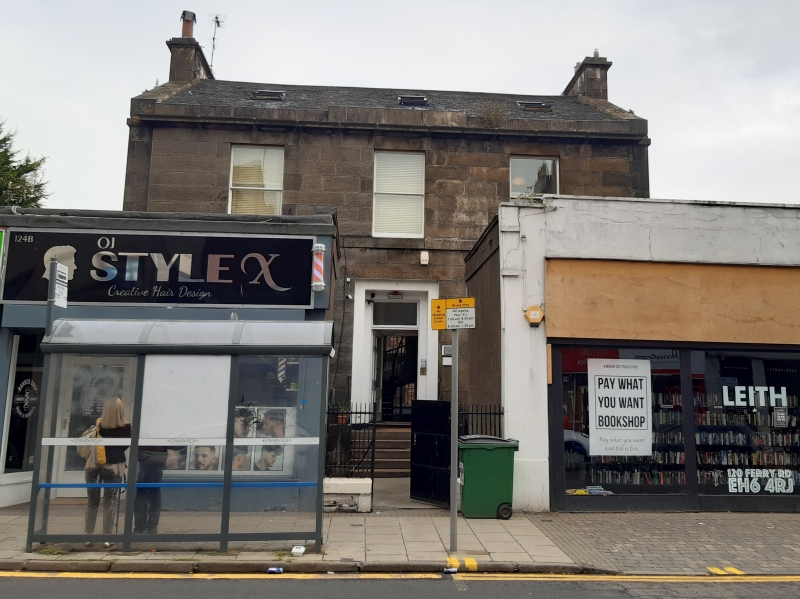
Early 19th century. 2-storey, 3-bay rectangular-plan, symmetrical classical house set back within former garden area (now projecting shops to left and right). Droved grey ashlar sandstone; raised base, string and blocking courses; projecting cornice. Recessed angles flank central block; blocking course raised at centre. Random rubble to rear and side elevations; droved long and short quoins; projecting cills; polished surrounds to openings.
S (ENTRANCE) ELEVATION: stone stairs to central doorway. Double-recessed surround; original timber panelled door with brass fittings; replacement opaque fanlight. Single windows to ground in bays to outer left and right; polished architraved panels below. Regular fenestration to 1st floor. Single storey shops flank entry blocking windows at ground.
N (REAR) ELEVATION: a-symmetrical disposition of openings. Door to ground off-set to left of centre; small square windows flanking. Single windows at ground in bays to outer left and right. Tall stair window in central bay; single windows to ground and 1st floors in bays to outer left and right; tripartite bowed dormers aligned above. Brick additions to right and left of house.
2-pane timber sash and case windows to S; various timber sash and case, bipartite and tripartite mullioned windows with upper hoppers elsewhere. Grey slate roof in diminishing courses; raised stone skews. Corniced ashlar apex stacks to E and W; circular can to W; octagonal can to E.
INTERIOR: converted to fit new function but retains original panelled doors, skirting boards and some detailed cornice work and ceiling roses. Some timber fireplaces remain in place; marble fireplace to original drawing room. Timber rail, cast-iron uprights and stone treads (covered in carpet) to rear stair. Some timber shutters remain in place; glazed vestibule door with side-lights and timber panelling. Shallow domed entrance hall with pendentives and foliate ceiling rose.
The 1853 Ordnance Survey map labels this property "Bainfield House" (note the change in spelling). The map also shows a formal parterre to the rear and a double-circular drive to the front. A small summer house was set against the N boundary and a pump-house just behind the house. Converted circa 1980 to accommodate a graphics company, much of the original has been retained (particularly inside) and that which can still be seen of the exterior remains true to its 19th century form.
External links are from the relevant listing authority and, where applicable, Wikidata. Wikidata IDs may be related buildings as well as this specific building. If you want to add or update a link, you will need to do so by editing the Wikidata entry.


Other nearby listed buildings
