Approximate Location Map
Large Map »
Latitude: 55.9471 / 55°56'49"N
Longitude: -3.1984 / 3°11'54"W
OS Eastings: 325255
OS Northings: 673323
OS Grid: NT252733
Mapcode National: GBR 8MH.MM
Mapcode Global: WH6SL.VS47
Plus Code: 9C7RWRW2+RJ
Entry Name: 1 Grassmarket, Edinburgh
Listing Name: 1 Grassmarket and 2 King's Stables Road
Listing Date: 10 April 1986
Category: C
Source: Historic Scotland
Source ID: 367810
Historic Scotland Designation Reference: LB28932
Building Class: Cultural
ID on this website: 200367810
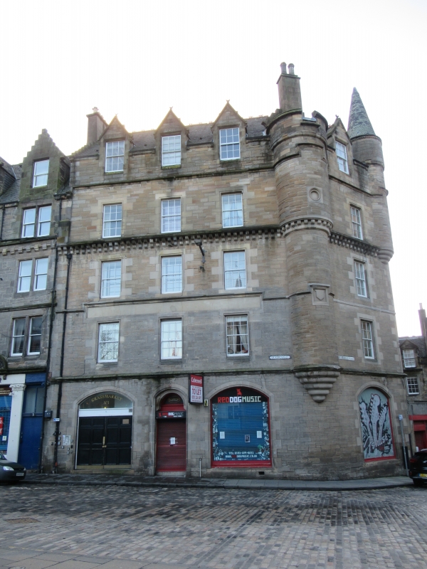
Circa 1875, rebuilt (after fire) James Maclean 1897, with later alterations and additions. 4-storey and attic tenement with Scots Baronial details including corner bartizans, on splayed corner s's Stables Road; 6-bay rear wing and projecting 3-storey wing to King's Stables Road; modern single storey triangular infill. Squared and snecked stugged sandstone with polished dressings; rear wing random rubble. Roll-moulded and tabbed surrounds to 1st and 2nd storey windows of principal block, shoulder-arched to 3rd; moulded string course between storeys; machicolated corbelled course between 2nd and 3rd; gabled dormerheads with crescent finials to attic windows breaking eaves.
NE (GRASSMARKET) ELEVATION: entrance in centre bay: timber panelled door with semicircular fanlight in segmental-arched moulded surround with horse-shoe arch within. Window (modern glazing) to right and 2-leaf timber panelled door to left in broad segmental-arched openings. Regularly fenestrated above. Crenellated corner bartizan tower with 2 carved panels corbelled out above ground floor to outer right (formerly had conical fish-scale slated roof).
N (KING'S STABLES ROAD) ELEVATION: window in broad segmental-arched opening to ground; regularly fenestrated above. Long and short quoins; corner bartizan with conical slated roof corbelled out at 3rd floor to right. Elevation of 2-storey crowstep-gabled projecting wing to outer right: modern garage entrances to ground; regularly fenestrated; carved panel and corbelled out apex stack above; small castellated corner bartizans at 2nd floor to right and left; chamfered corner to Lady Wynd.
REAR WING: regularly fenestrated. Moulded string course below attic level; crowstepped gable to centre with wallhead stack and moulded arch over window; small corner bartizan to outer right.
12-pane glazing in timber sash and case windows. Grey slates; decorative terracotta ridge tiles. Corniced stacks with some octagonal cans.
Townscape importance as western termination to Grassmarket. The long rectangle of Grassmarket was already a suburb and a secondary market place by 1500. After the Battle of Flodden in 1513 the city walls were strengthened and the Grassmarket and Cowgate enclosed by the Flodden Wall. Agricultural produce was sold in the Grassmarket until well into the 20th century; old photographs show upended carts and the bars and hostels associated with the market. It was also a place of public execution.
External links are from the relevant listing authority and, where applicable, Wikidata. Wikidata IDs may be related buildings as well as this specific building. If you want to add or update a link, you will need to do so by editing the Wikidata entry.


Other nearby listed buildings
