Approximate Location Map
Large Map »
Latitude: 55.948 / 55°56'52"N
Longitude: -3.1948 / 3°11'41"W
OS Eastings: 325483
OS Northings: 673422
OS Grid: NT254734
Mapcode National: GBR 8NH.C8
Mapcode Global: WH6SL.WRVJ
Plus Code: 9C7RWRX4+63
Entry Name: 98 Grassmarket, Edinburgh
Listing Name: 98 Grassmarket and 105 West Bow
Listing Date: 21 April 1969
Category: A
Source: Historic Scotland
Source ID: 367829
Historic Scotland Designation Reference: LB28943
Building Class: Cultural
ID on this website: 200367829
Location: Edinburgh
County: Edinburgh
Town: Edinburgh
Electoral Ward: City Centre
Traditional County: Midlothian
Tagged with: Tenement
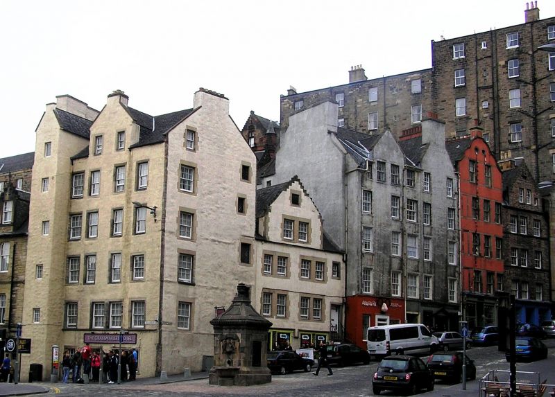
Early 17th century with later alterations and additions. 5-storey and attic tenement with gabled stair tower to left and 4-bays with nepus gable to Grassmarket and 2-bay gable with wallhead stack to West Bow. Yellow harled with stone margins.
SE (GRASSMARKET) ELEVATION: advanced pitch-roofed stair tower to left with 5 small windows lighting stair and small wallhead stack (see Notes). Recessed 4-bay block to right: small window to left at ground, timber boarded door to centre and modern window to right. String course between ground and 1st floors. Regularly fenestrated; paired windows to centre at 1st floor; 2 small windows in nepus gable to attic.
E (WEST BOW) ELEVATION: timber boarded door to right at ground; blocked door with inscription to outer right (see Notes); single windows to left at 1st, 2nd, 3rd 4th and attics; 4 smaller, irregularly placed windows with diamond-pane glazing to right.
12-pane glazing in timber sash and case windows; fixed diamond-paned glazing to West Bow. Massive end stack to W; corniced apex stacks with circular cans to gables. Grey slates. Ashlar-coped skews.
Part of an inscribed lintel and the bolection moulding of a blocked up door can be seen to the right of the door on the E elevation; the inscription reads '(blessed be) God for all his Gifts 1616.' The lines of the former string courses stepping up over windows and door can also be seen under the harling at ground, 1st and 2nd floors on this elevation. The long rectangle of Grassmarket was already a suburb and a secondary market place by 1500. After the Battle of Flodden in 1513 the city walls were strengthened and the Grassmarket and Cowgate enclosed by the Flodden Wall. Agricultural produce was sold in the Grassmarket until well into the 20th century; old photographs show up-ended carts and the bars and hostels associated with the market. It was also a place of public execution. Nos 98 Grassmarket and 105 West Bow are now (2000) a hotel.
External links are from the relevant listing authority and, where applicable, Wikidata. Wikidata IDs may be related buildings as well as this specific building. If you want to add or update a link, you will need to do so by editing the Wikidata entry.


Other nearby listed buildings
