Approximate Location Map
Large Map »
Latitude: 55.9463 / 55°56'46"N
Longitude: -3.1856 / 3°11'8"W
OS Eastings: 326051
OS Northings: 673217
OS Grid: NT260732
Mapcode National: GBR 8QH.6X
Mapcode Global: WH6SM.1SBW
Plus Code: 9C7RWRW7+GQ
Entry Name: 43-45 Nicolson Street, Edinburgh
Listing Name: 1, 2 and 3 Nicolson Square and 43 and 45 Nicolson Street
Listing Date: 29 April 1977
Category: B
Source: Historic Scotland
Source ID: 369288
Historic Scotland Designation Reference: LB29411
Building Class: Cultural
ID on this website: 200369288
Location: Edinburgh
County: Edinburgh
Town: Edinburgh
Electoral Ward: Southside/Newington
Traditional County: Midlothian
Tagged with: Architectural structure
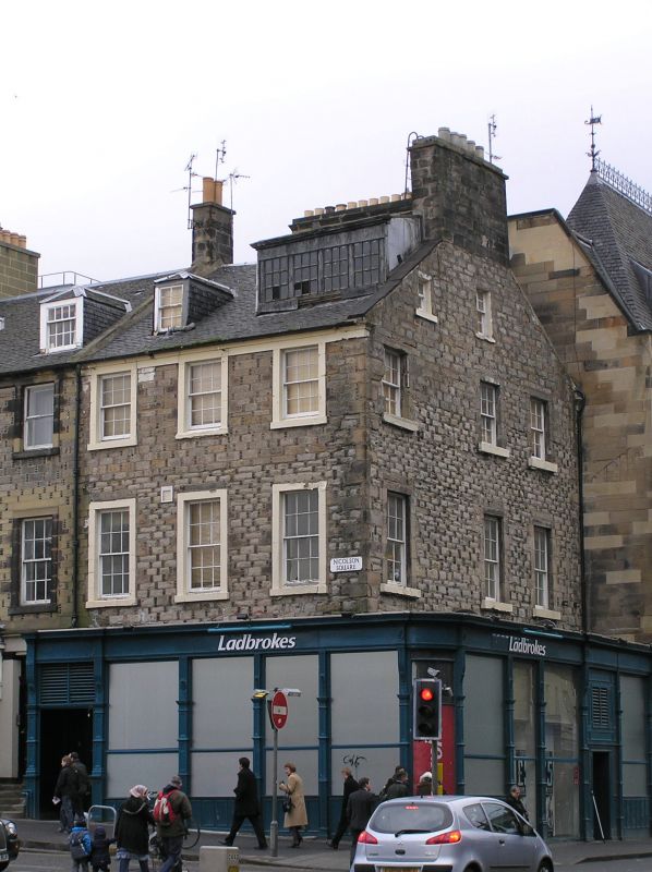
Later 18th century. 3-storey and attic, 6 x 3-bay corner tenement with altered commercial premises to ground. Later, projecting, flat-roofed, single-storey shop fronts to Nicolson Square (S) and to Nicolson Street. (W), curving at corner. Coursed rubble with Aberdeen bonding. Raised margins, some painted. S elevation with off-centre steps leading to timber panelled entrance door. Shop front to No 1 Nicolson Square and Nos 43-35 Nicolson Street with corniced timber fascia, narrow, decorative timber pilasters and mullions and panelled timber stallrisers. 3 piended dormers, 1 later, sloping roofed dormer.
Predominantly 12-pane timber sash and case windows to upper storeys, plate glass to shops. Grey slates. Coped gable stacks. Raised skews.
This later 18th century tenement building forms the North East corner of Nicolson Square and contributes significantly to the surrounding streetscape. It is an integral part of an early Classical planned square. The Aberdeen bonding is a distinctive and unusual detail and the projecting corner shop front, with its decorative timber pilasters and mullions is a good survival of its type. The planned square with tenements surrounding a communal garden was a particular feature of developing Edinburgh in the late 18th and early 19th centuries and they remain an important characteristic of the townscape.
Projecting single storey shop fronts evolved during the 19th century and arose from a desire for shops to have more space, light and a better area for displaying goods. They utilise the space between the building and the pavement, often where a garden or access to a basement has been. They are found throughout Scotland, although are particularly prevalent in Edinburgh. The Ordnance Survey Map of 1893-4 depicts this tenement with platts and steps over a basement which suggests that the projecting shop fronts here date from the late 19th or early 20th century.
The development of Nicolson Square dates from 1765 when the city was beginning to expand to the South and the land here was feued from the Estate of Lady Nicolson. This tenement forms part of a row of tenements which still survive on the N side of the Square.
List description revised as part of Edinburgh Holyrood Ward resurvey 2007-08.
External links are from the relevant listing authority and, where applicable, Wikidata. Wikidata IDs may be related buildings as well as this specific building. If you want to add or update a link, you will need to do so by editing the Wikidata entry.


Other nearby listed buildings
