Approximate Location Map
Large Map »
Latitude: 55.9432 / 55°56'35"N
Longitude: -3.1844 / 3°11'3"W
OS Eastings: 326123
OS Northings: 672876
OS Grid: NT261728
Mapcode National: GBR 8QK.G0
Mapcode Global: WH6SM.1WX6
Plus Code: 9C7RWRV8+77
Entry Name: 27-29 Buccleuch Street, Edinburgh
Listing Name: 27-29 Buccleuch Street Including Boundary Wall
Listing Date: 8 March 1995
Category: B
Source: Historic Scotland
Source ID: 371168
Historic Scotland Designation Reference: LB30320
Building Class: Cultural
ID on this website: 200371168
Location: Edinburgh
County: Edinburgh
Town: Edinburgh
Electoral Ward: Southside/Newington
Traditional County: Midlothian
Tagged with: Architectural structure
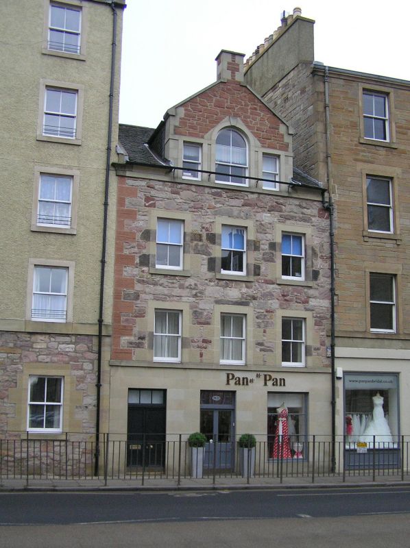
Circa 1760. 3-storey and attic, 3-bay tenement with shop at ground floor, Venetian window to attic gable, and stairtower to rear; now forms end of terrace. Cream and pink sandstone rubble with ashlar dressings; rendered side gable wall. Projecting cills.
W (ENTRANCE) ELEVATION: later tenement door with glazed sidelight and fanlight in bay to outer left; 1960s plate glass shopfront in
bays to centre and outer right. Single windows to each bay at 1st
and 2nd floors above. Central gabled and keystoned Venetian window
above eaves (plastic repairs to dressings); gablehead stack.
E (REAR) ELEVATION: 2-bay. Advanced bowed stairtower in bay to
outer right; single windows between each floor. Single windows to each
floor in bay to outer left and in return to stairtower; 3rd floor window breaking eaves. Carved heraldic panel set to lower left of 1st floor window: initialed JG and CP, and dated 1687.
N (SIDE) ELEVATION: rendered; no openings. 4-pane sash and case windows. Grey slate roof; coped gablehead stack.
BOUNDARY WALL: rubble boundary wall adjoining to E.
The carved stone appears to have belonged to John Gibson, writer, and
Christian Porteous, who purchased the site in about 1687. A feu
contract of 17/4/1778 for the neighbouring "Buccleuch Pend"
tenement (demolished 1947) states that the feu was bounded to the
south by a tenement belonging to John Gibson. As the tenement does not
appear on Cooper's 1759 map, it seems likely that it was constructed shortly afterwards by the son or grandson of Gibson and Porteous, at which time the date stone was incorporated.
External links are from the relevant listing authority and, where applicable, Wikidata. Wikidata IDs may be related buildings as well as this specific building. If you want to add or update a link, you will need to do so by editing the Wikidata entry.


Other nearby listed buildings
