Approximate Location Map
Large Map »
Latitude: 55.9358 / 55°56'8"N
Longitude: -3.1897 / 3°11'22"W
OS Eastings: 325777
OS Northings: 672052
OS Grid: NT257720
Mapcode National: GBR 8PM.DP
Mapcode Global: WH6SS.Z28D
Plus Code: 9C7RWRP6+84
Entry Name: 59 Grange Road, Edinburgh
Listing Name: 57 and 59 Grange Road Including Boundary Walls
Listing Date: 15 January 1992
Category: C
Source: Historic Scotland
Source ID: 371284
Historic Scotland Designation Reference: LB30392
Building Class: Cultural
ID on this website: 200371284
Location: Edinburgh
County: Edinburgh
Town: Edinburgh
Electoral Ward: Southside/Newington
Traditional County: Midlothian
Tagged with: Villa
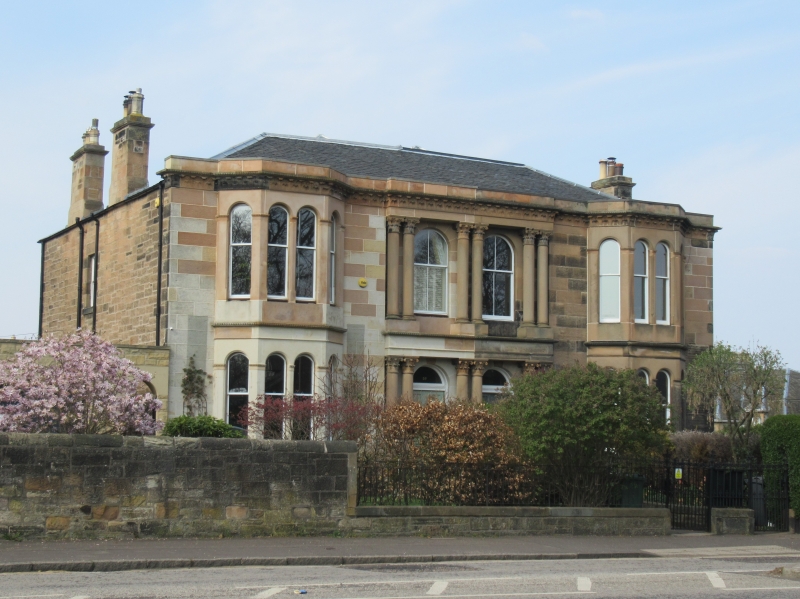
Circa 1866. 2-storey, 4-bay symmetrical rectangular-plan double villa. Squared and snecked sandstone rubble; lightly stugged ashlar at S elevation. Paired Corinthian columns flanking and dividing 2 centre bays at ground and 1st floors. Base course; acanthus-leaf frieze and cornice; blocking course; round-arched windows with pilaster mullions and stop-chmfered reveals.
S (ENTRANCE) ELEVATION: central slightly advanced entrance bays with columns as above and dividing entablature between floors; round-arched doorways with panelled doors and plate glass fanlights; single windows above. Full-height 4-light canted windows with dividing cornices flanking to outer left and right. Single storey flat-roofed double garage (1982) adjoined by pedestrian gateway to W.
W ELEVATION: single window at 1st floor.
EW ELEVATION: 2 single windows at 1st floor.
N ELEVATION: not seen 1990.
Plate glass sash and case windows (replacements at No 59); 4-pane sash and case windows at S elevation central 1st floor bays. Grey slate piended roof; lead flashing; 4 shouldered and corniced wallhead stacks; some moulded octagonal cans.
INTERIORS: not seen 1990.
BOUNDARY WALLS: low coped boundary wall to street with remnants of cast-iron railings at centre, rising to approximately 2m to W and round into Mansionhouse Road to E.
External links are from the relevant listing authority and, where applicable, Wikidata. Wikidata IDs may be related buildings as well as this specific building. If you want to add or update a link, you will need to do so by editing the Wikidata entry.


Other nearby listed buildings
