Approximate Location Map
Large Map »
Latitude: 55.9376 / 55°56'15"N
Longitude: -3.1815 / 3°10'53"W
OS Eastings: 326289
OS Northings: 672250
OS Grid: NT262722
Mapcode National: GBR 8RM.10
Mapcode Global: WH6ST.307Y
Plus Code: 9C7RWRQ9+39
Entry Name: Jewish Burial Ground, Sciennes House Place, Edinburgh
Listing Name: Sciennes House Place, Jewish Burial Ground with Graveyard Walls, Gates and Railings
Listing Date: 3 May 1990
Category: B
Source: Historic Scotland
Source ID: 371448
Historic Scotland Designation Reference: LB30476
Building Class: Cultural
ID on this website: 200371448
Location: Edinburgh
County: Edinburgh
Town: Edinburgh
Electoral Ward: Southside/Newington
Traditional County: Midlothian
Tagged with: Architectural structure
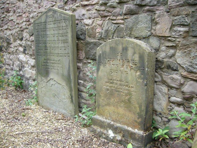
Formed 1820, comprised of 1-24th of an acre, retained by existing sandstone rubble walls of varying dates, to S, E and W, probably largely 18th century. Lower wall to N, later 19th century, squared and snecked sandstone with saddleback ashlar coping; wrought-iron railings and 2-leaf gate.
Gravestones: 29 graves with variety of gravestones and wall monuments, dating from between 1820 and 1867, inscribed in Hebrew characters. Tripartite, Greek wall monument to E wall.
As the first Jewish Burial Ground in Scotland (pre-dating the Jews' Enclosure at the Glasgow Necropolis by about 5 years), the Sciennes House Place cemetery is of historic importance. 2 stones are dated 1817 and 1818, but the ground was only purchased in 1820, so these were probably carved at this date. The Jewish community was strong in Newington, where, in 1867, the next Edinburgh burial ground was opened, at Echo Bank. The ground was very secluded for many years, only to become apparent with the formation of Braid Place to N, later in the century. The Causewayside Police Station to E, stands on ground formerly known as Jews' Close. The ground is currently in the care of Edinburgh District Council.
External links are from the relevant listing authority and, where applicable, Wikidata. Wikidata IDs may be related buildings as well as this specific building. If you want to add or update a link, you will need to do so by editing the Wikidata entry.


Other nearby listed buildings
