Approximate Location Map
Large Map »
Latitude: 55.4775 / 55°28'38"N
Longitude: -2.5559 / 2°33'21"W
OS Eastings: 364958
OS Northings: 620546
OS Grid: NT649205
Mapcode National: GBR B5L3.F9
Mapcode Global: WH8YH.QL28
Plus Code: 9C7VFCGV+XJ
Entry Name: 3-5 Castlegate, Jedburgh
Listing Name: 3-5 (Inclusive Nos) Castlegate (To Under Nags Head Close)
Listing Date: 16 March 1971
Category: B
Source: Historic Scotland
Source ID: 380070
Historic Scotland Designation Reference: LB35484
Building Class: Cultural
ID on this website: 200380070
Location: Jedburgh
County: Scottish Borders
Town: Jedburgh
Electoral Ward: Jedburgh and District
Traditional County: Roxburghshire
Tagged with: Tenement
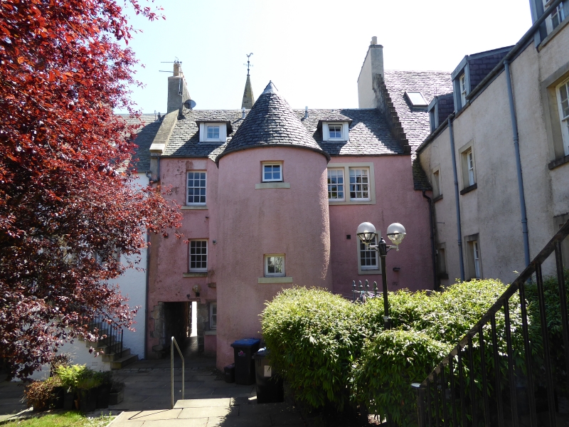
Late 17th century with later alterations. 3-storey and attic 3-bay tenement with shop and pedestrian pend at ground; rectangular windows to all bays; modern stair tower to rear. Harled with painted ashlar margins and cills. 2 left bays advanced (with return to left before adjoining No 7), under crowstepped gable with ball finial and attic window; return to right with glazed door and letterbox fanlight to shop. Right bay with pend to right, rubble margins with chamfered arrises, (to Under Nags Hea d Close) and square window to left at ground; single windows to upper floor.
Irregular harled rear facade with concrete cills; at centre, projecting semi-circular stair tower (c. 1978) with door at ground and conical roof; single bays to either side, upper right window bipartite; pair of little piend-roofed dormers.
12-pane timber sash and case windows; 9-pane vertical pivot attic window, 4-pane casements to dormers and stair; plate glass window at ground. Grey slates.
Recently thoroughly restored; earlier the front had been flush with the rest of the street, the right bay having a smaller gable and there being a further small bay to the left. The drum stair tower replaces a demolished range which extended to the rear. Its current form may be closer to its original plan. Part of the continuous B group to Market Place.
External links are from the relevant listing authority and, where applicable, Wikidata. Wikidata IDs may be related buildings as well as this specific building. If you want to add or update a link, you will need to do so by editing the Wikidata entry.


Other nearby listed buildings
