Approximate Location Map
Large Map »
Latitude: 55.4779 / 55°28'40"N
Longitude: -2.5516 / 2°33'5"W
OS Eastings: 365232
OS Northings: 620592
OS Grid: NT652205
Mapcode National: GBR B5M3.C4
Mapcode Global: WH8YH.SK4X
Plus Code: 9C7VFCHX+59
Entry Name: The Piper's House, Duck Row, Jedburgh
Listing Name: Duck Row, the Piper's House
Listing Date: 16 March 1971
Category: B
Source: Historic Scotland
Source ID: 380110
Historic Scotland Designation Reference: LB35518
Building Class: Cultural
ID on this website: 200380110
Location: Jedburgh
County: Scottish Borders
Town: Jedburgh
Electoral Ward: Jedburgh and District
Traditional County: Roxburghshire
Tagged with: House
Early 17th century core, rebuilt much later. 2-storey 3-bay crowstepped gabled hosue, with single bay house to N.
Harled, raised margins.
E ELEVATION: 2-storey 3-bay house to S, window to each floor and bay; door to left of central window. Plaque in lintel of central 1st floor window. Single bay house to N; bipartite windows to each floor, door to left.
S ELEVATION: gabled and elevation with single window to both floors at outer left. 2 corbel stones just above eaves level. Gablehead stack.
W ELEVATION: to N, single storey with bipartite window, harled; mutual gable and stack to right. 3 bays to S, 2 left bays harled with door to left and window to right; right bay blank rubble, with basement.
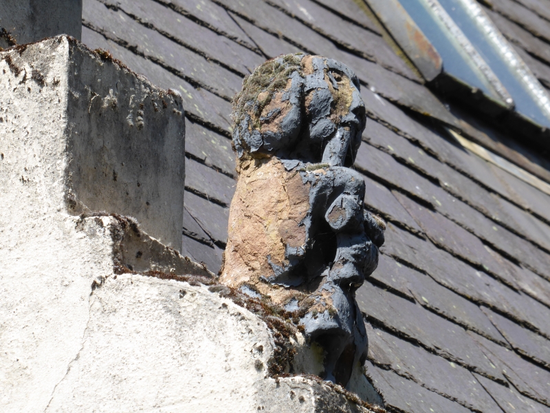
4-pane timber sash and case windows (plate glass to No 2). Grey slates; small roof-lights; coped stacks. Crowsteps, moulded skewputts (N missing); figure of squatting man stands on NE skewputt (apparently the piper).INTERIOR: not seen 1992.1st floor flat and ground floor stores.
Built by Adam Ainslie at the beginning of the 17th century. His initials and those of his wife IA (Janet Ainslie) can be seen over the lintel of the central window on the 1st floor, as well as the date 1605. This window is in the place of a door, originally approached by a stone forestair, which was however taken down shortly before 1730. A further carved lintel bearing inscriptions of Adam Ainslie was found during building work in 1896. The house was sold in 1726 by Janet Ainslie, again in 1730 for 500 merks, and a last time in 1780, to William Rutherford, merchant for $40. It remained in this family until Alexander Scott, the owner of Queen Mary's House, bought it in 1894 for $120. One of gables is reputedly four feet thick. Robin Hastie, the last town piper, is supposed to have occupied a portion of the house; his family, according to Sir Walter Scott, had occupied the post for 3 centuries. By the time of his death in the early 19th century, according to Scott "old age had rendered Robin a wretched performer but he knew several old songs and tunes, which have probably died with him"
The house originally terminated the Canongate, the adjoining house being demolished to make way for the by-pass in 1972. It also had 3 dormers at that time. The projecting corbes on the S wall are a puzzle. Group with 1,2 and 3 Duck Row and the Canongate Bridge (see separate listings).
External links are from the relevant listing authority and, where applicable, Wikidata. Wikidata IDs may be related buildings as well as this specific building. If you want to add or update a link, you will need to do so by editing the Wikidata entry.


Other nearby listed buildings
