Approximate Location Map
Large Map »
Latitude: 56.1123 / 56°6'44"N
Longitude: -3.1583 / 3°9'29"W
OS Eastings: 328067
OS Northings: 691660
OS Grid: NT280916
Mapcode National: GBR 29.LY4L
Mapcode Global: WH6RV.GM8M
Plus Code: 9C8R4R6R+WM
Entry Name: 34-36 Kirk Wynd, Kirkcaldy
Listing Name: 34 and 36 Kirk Wynd with Boundary Walls
Listing Date: 28 January 1971
Category: B
Source: Historic Scotland
Source ID: 381076
Historic Scotland Designation Reference: LB36321
Building Class: Cultural
ID on this website: 200381076
Location: Kirkcaldy
County: Fife
Town: Kirkcaldy
Electoral Ward: Kirkcaldy Central
Traditional County: Fife
Tagged with: House
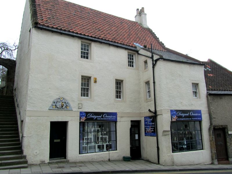
Early 18th century, possibly incorporating earlier fabric. 3-storey and 2-storey, crowstepped house in irregular terrace to S and on ground falling to W. Harled with painted margins. Re-used strapwork cartouche. Dividing course.
W (PRINCIPAL) ELEVATION: timber door to outer left with cartouche above dated '1638' and initialled 'MA ML', enlarged window to right and further door beyond; advanced bay, also with enlarged window, to outer right. 2 windows to left of centre at 1st floor, window to advanced bay and further window on return to left; 2 windows close to eaves at 2nd floor and further small window below catslide roof on left return of advanced bay.
N ELEVATION: steps (listed separately) up to E. Small window to outer right at ground, further window to outer right and blinded window to outer left at 2nd floor.
E ELEVATION: segmental-headed door to centre and 2 windows to left; wall of Parish Church graveyard (listed separately) abutting to right of centre and further window beyond; 2 rooflights above.
12-pane glazing pattern in timber sash and case windows; fixed small-pane glazing to ground W and casement windows to E. Pantiles with deep slate eaves easing course; advanced bay to W right slated. Coped and harled grouped stacks with cans.
INTERIOR: 1st floor room to rear with plaster masque and room to front with exposed beams and carved ship in roundel.
BOUNDARY WALLS: coped rubble boundary walls to rear (see Notes).
Now used as offices, this building was the home of Matthew Anderson, elder in the parish church and local meal dealer and maltster, whose coat-of-arms appears in the strapwork cartouche which was probably transferred from an earlier building on this site. A blocked doorway in the NE corner of the boundary wall would have given access to the churchyard.
External links are from the relevant listing authority and, where applicable, Wikidata. Wikidata IDs may be related buildings as well as this specific building. If you want to add or update a link, you will need to do so by editing the Wikidata entry.


Other nearby listed buildings
