Approximate Location Map
Large Map »
Latitude: 58.9823 / 58°58'56"N
Longitude: -2.9591 / 2°57'32"W
OS Eastings: 344967
OS Northings: 1010965
OS Grid: HY449109
Mapcode National: GBR M41Z.Z04
Mapcode Global: WH7C4.JH3G
Plus Code: 9CCVX2JR+W9
Entry Name: 1 And 6 The Strynd, Kirkwall
Listing Name: 1-6 (Inclusive Numbers) the Strynd, North Side
Listing Date: 8 December 1971
Category: B
Source: Historic Scotland
Source ID: 381512
Historic Scotland Designation Reference: LB36670
Building Class: Cultural
ID on this website: 200381512
Location: Kirkwall
County: Orkney Islands
Town: Kirkwall
Electoral Ward: Kirkwall East
Traditional County: Orkney
Tagged with: Architectural structure
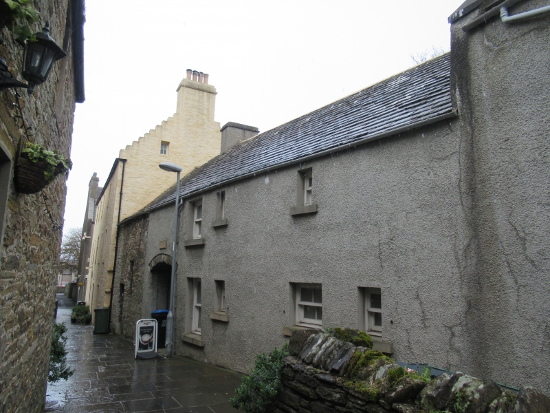
17th century with substantial 18th century re-working; 1703, additions; refurbished, 1979. 2-storey, (single storey to rear, N and E), T-plan complex of 6 properties, built on ground rising to E, comprising: row of 4, irregular, rectangular-plan, houses facing The Strynd, (Numbers 2, 3, 4 and 5) with forestair to W end giving access to rears and to Number 6; freestone, segmental arch over pend to E end giving access to 2-storey, 3-bay, near-symmetrical rectangular-plan crowstep-gabled house (Number 1 to W, Number 6 to E) at right angles, forming small courtyard. Harled with polished sandstone ashlar and cement dressings. Chamfered reveals to windows to Numbers 1 and 6; block cills to remainder.
NUMBER 2 (to W); N (PRINCIPAL) ELEVATION: in courtyard. Window at each floor in bay to centre. Part glazed modern timber -panelled door at ground in bay to left. Window at each floor in bay to outer left. Deep-set boarded door at ground in bay to penultimate right. Window at 1st floor over pend in bay to outer right. S (REAR, THE STRYND) ELEVATION: irregular 3-bay (4-bay at ground). Window at each floor in bay to centre. Window at each floor in bay to right. Window at ground in bay to outer right. Window at each floor in bay to left. Pend entrance to outer left.
NUMBERS 3, 4 and 5; N (PRINCIPAL) ELEVATIONS: NUMBERS 3 and 4: 3-bay. Window at each floor in bays to centre and left. Door, (architraved, part-glazed timber-panelled to Number 3 with modern date panel, '1703' above; boarded to Number 4) at ground in bay to right; window at 1st floor. NUMBER 5: 4-bay. Part-glazed timber panelled door at ground in bay offset to left of centre; non-aligned window at 1st floor above. Window at ground in bay to outer left. Window at 1st floor in bay to right. Window at each floor in bays to penultimate and outer right. S (REAR) ELEVATIONS: single storey, irregular 3-bay elevation spanning range. Part-glazed timber-panelled door, breaking eaves in bay offset to left of centre; part-glazed timber-panelled door offset to right; window in bay to outer right.
NUMBERS 1 and 6: E (NUMBER 1) ELEVATION: non-aligned window at each floor in bays to centre and left. Part-glazed timber-panelled door at ground in bay to right; window at 1st floor above. W (NUMBER 6) ELEVATION: single storey. Part-glazed, timber-panelled door in bay to left. Window in each bay remaining.
4-pane timber sash and case windows. Traditional graded stone tiled roofs; stone ridges; stone skews; harled, corniced gablehead and ridge stacks; predominantly uPVC rainwater goods.
INTERIORS: not seen, 1998.
B-group with the Strynd Walls and the buildings on the south side, the passageway formed links Broad Street and King Street. Originally 2 houses, now 6 properties, this group lines the north side of The Strynd, a narrow, flagstone-paved passage between two high, medieval stone walls. Originally called the King's Passage, the Strynd was roofed temporarily during the Second World War to act as an air raid shelter. The rubble houses were re-harled and re-roofed in traditional flagstone by the Orkney Islands Council in 1979. The L-plan group comprising Numbers 1, 6 and 3 was built by Andrew Morrison, a church treasurer, and was visited by William IV (before his accession) in 1785; it later became the manse of the secession church. The house to the east, comprising Numbers 4 and 5, was at the same time a cathedral manse. The rear portion of this block in now converted to the Strynd Community room. An important group of structures having considerable streetscape value and providing a unique and renowned space within Kirkwall.
External links are from the relevant listing authority and, where applicable, Wikidata. Wikidata IDs may be related buildings as well as this specific building. If you want to add or update a link, you will need to do so by editing the Wikidata entry.


Other nearby listed buildings
