Approximate Location Map
Large Map »
Latitude: 58.9822 / 58°58'55"N
Longitude: -2.9596 / 2°57'34"W
OS Eastings: 344936
OS Northings: 1010954
OS Grid: HY449109
Mapcode National: GBR M41Z.YRF
Mapcode Global: WH7C4.HHVJ
Plus Code: 9CCVX2JR+V4
Entry Name: 4 Broad Street, Kirkwall
Listing Name: 4 Broad Street
Listing Date: 8 December 1971
Category: B
Source: Historic Scotland
Source ID: 381516
Historic Scotland Designation Reference: LB36672
Building Class: Cultural
ID on this website: 200381516
Location: Kirkwall
County: Orkney Islands
Town: Kirkwall
Electoral Ward: Kirkwall East
Traditional County: Orkney
Tagged with: Townhouse
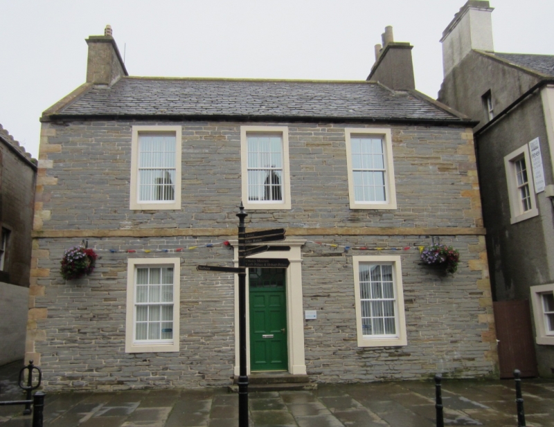
Earlier 19th century. 2-storey, 3-bay, rectangular-plan symmetrical plain classical town house (converted to offices); lower 2-bay wing at rear forming L-plan with stair tower to angel; crowsteps to rear. Re-pointed squared and coursed rubble with polished ashlar and cement dressings. Band course between floors; eaves course. Plain cement margins to windows; long and short quoins.
W (PRINCIPAL) ELEVATION: pilastered and corniced doorpiece at ground in bay to centre; timber panelled door with decorative geometric fanlight; window at 1st floor above. Window at each floor in each bay flanking.
N (STRYND) ELEVATION: window set to left at ground in gabled block to right. Blocked window at ground with window at 1st floor in each of 2-bay wing to left.
12-pane timber sash and case windows. Graded grey slate roof; stone ridge; harled, corniced gablehead stack to S; ashlar, corniced stack to N; extended stack to rear (E) wing; stone skews and thack stanes to W; predominantly cast-iron rainwater goods.
INTERIOR: converted as offices; not fully seen, 1998.
Standing adjacent to Number 6 Broad Street (listed separately), the pair provide a strong terminal to the east end of Castle Street,. Along with Number 8, to the rear of Number 6 (listed separately) they form a fine group. Number 4 is recorded in 1971 as comprising four properties; the west house was a Secession Church manse, the house to the east an established Church manse in the later 18th century.
External links are from the relevant listing authority and, where applicable, Wikidata. Wikidata IDs may be related buildings as well as this specific building. If you want to add or update a link, you will need to do so by editing the Wikidata entry.


Other nearby listed buildings
